File:Baleville RS Plan.jpg
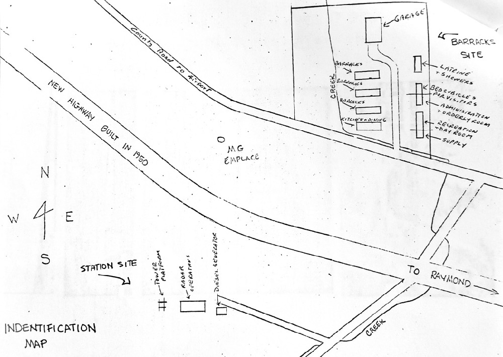
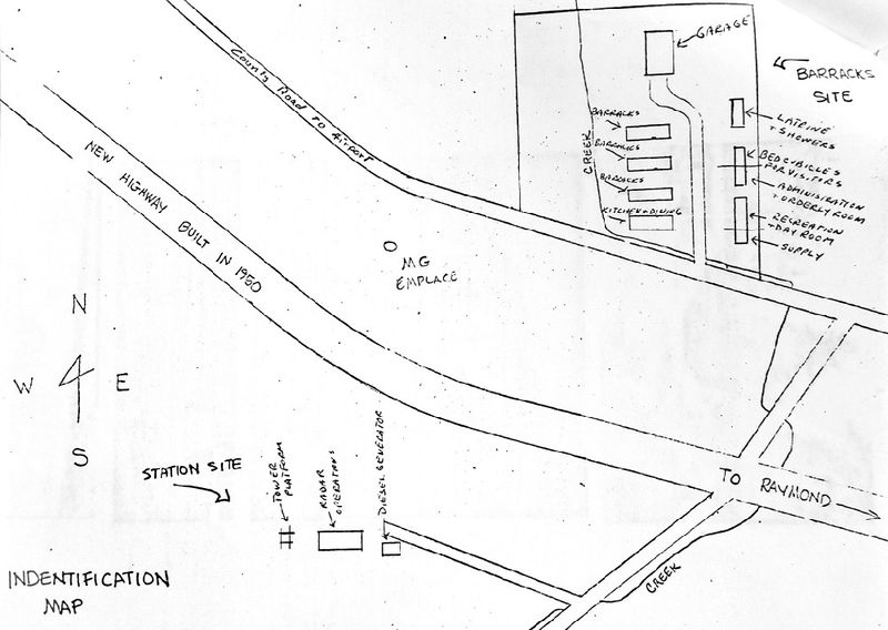
Baleville WWII Radar Site Plan, unattributed sketch at Pacific County Historical Society and Museum, photo by John Stanton 16 Aug 2018
File history
Click on a date/time to view the file as it appeared at that time.
| Date/Time | Thumbnail | Dimensions | User | Comment | |
|---|---|---|---|---|---|
| current | 02:59, 19 August 2018 | | 1,000 × 710 (159 KB) | John Stanton (Talk | contribs) | Baleville WWII Radar Site Plan, unattributed sketch at Pacific County Historical Society and Museum, photo by John Stanton 16 Aug 2018 |
- Edit this file using an external application (See the setup instructions for more information)
File usage
The following page links to this file:
Metadata
| Camera manufacturer | samsung |
|---|---|
| Camera model | SM-G955U |
| Exposure time | 1/60 sec (0.0166666666667) |
| F Number | f/1.7 |
| ISO speed rating | 80 |
| Date and time of data generation | 11:48, 16 August 2018 |
| Lens focal length | 4.25 mm |
| Orientation | Normal |
| Horizontal resolution | 72 dpi |
| Vertical resolution | 72 dpi |
| Software used | Photos 3.0 |
| File change date and time | 11:48, 16 August 2018 |
| Exposure Program | Normal program |
| Exif version | 2.2 |
| Date and time of digitizing | 11:48, 16 August 2018 |
| Meaning of each component |
|
| APEX shutter speed | 5.906 |
| APEX aperture | 1.53 |
| APEX brightness | 2.61 |
| APEX exposure bias | 0 |
| Maximum land aperture | 1.53 APEX (f/1.7) |
| Metering mode | Pattern |
| Light source | Unknown |
| Flash | Flash did not fire |
| User comments | JKJK�
???��!���??���?�������?���?����������������������?�?�?�??������8?��??��?D??+ ��0??? \��????o���E�??L?��Q3��Q3��Q3��Q3��Q3��Q3��Q3��aU��aU��af��Q3��Q3��Q3��A"��Q3��?���Q3��Q3��A"��A"��P"��Q3��Q3��af��Q3��Q3��Q3��@"��Q3��@"��Q3��Q3��Q3��Q3��A"��Q3��P"��P"��Q3��af��af��af��Q3��Q3��@"��Q3��Q3��Q3��Q3��Q3��Q3��Q3��P"��P"��P"��af��af��af��Q3��Q3��Q3��Q3��Q3��Q3��Q3��Q3��Q3��P"��P"��P"��`3��`3��af��af��af��af��Q3��Q3��Q3��af��Q3��Q3��Q3��P"��P"��P"��`3��`3��`3��af��af��af��Q3��Q3��Q3��af��Q3��Q3��Q3��P"��`3��`3��`3��`3��`3��af��af��Q3��Q3��Q3��af��af��Q3��Q3��Q3��P"��P"��`3��`3��`3��`3��af��af��Q3��Q3��Q3��af��af��Q3��Q3��Q3��P"��P"��`3��`3��`3��`3��`3��af��Q3��Q3��Q3��af��af��Q3��af��Q3��P"��P"��`3��`3��`3��`3��`3��Q3��Q3��Q3��Q3��af��af��Q3��af��Q3��P"��P"��`3��`3��`3��P"��P"��Q3��Q3��Q3��Q3��af��Q3��af��af��Q3��P"��P"��P"��P"��P"��P"��P"��Q3��Q3��Q3��Q3��af��Q3��qf��af��P"��P"��P"��P"��P"��P"��P"��P"��Q3��Q3��Q3��Q3��Q3��Q3��af��af��P"��P"��P"��P"��P"��P"��P"��P"��P"��Q3��Q3��Q3��Q3��?? �af��af��P"��P"��P"��P"��@"��P"��@"��@"��A"��A"��Q3��Q3��?? �?? �af��af��Q3��Q3��Q3��Q3��Q3��A"��A"��A"��A"��A"��Q3��Q3��?? �?? ���������?�������`�������e����!?���<�������������������������*�?�?�*�?�?�*�?�?�*�?�?�*�?�?�*�?�?�2�?�p���������������������������������������������������?���?� ����� �����J���?!����^�����^�������������������?���?$e����!e����!?���?#?���<�?���<�?���?�?�����?%���?��?7��������������������������������������������������������������������������������������3}��??������������������������������������������������������������������������������������������������������������FAFA��?�?�q���?�(���??3�����FAFA(�?� ��� �v���???�?� ��� �v���???�?�??,���v���???�?�??,���v���???�?�??,���v���???�?���?? �v���???�?���?? �v���???�?���?? �v���???�?�????��v���???�?�????��v���???�?�????��v���???�?�N�??$�v���???�?�N�??$�v���???�?�N�??$�v���???�?���?? �v���???�?���?? �v���???�?���?? �v���???�?�&�?? �v���???�?�&�?? �v���???�?�K�=���v���???�?�K�=���v���???�?�K�=���v���???�?�K�=���v���???�?�????F�v���???�?�????F�v���???�?�??����v���???�?�??����v���???�?�??����v���???�?�??����v���???�?�??����v���???�?�??����v���???�?���????v���???�?���????v���???�?���????v���???�?���????v���???�?���????v���???�?���????v���???�?�??????v���???�?�??????v���???�?�??????v���???�?���?��? �����?�~�?�^�FAFA����������������������������������������������������������������������������������������������������������?�?�����?�?�����?�?�����?�?�����?�������?�������?�?�����?�?�����?�?�����?�?�����?�?�����?�?�����?�?�����?�?�����?�?�����?�?�����?�?�����?�?�����?�?�����?�?�����?�?�����?�?�����?�?�����?�?�����?�?�����?�J�����?�?�����?�?�����?�?�����?�?�����?�?�����?�?�����?�?�����?�?�����?�?�����?�?�����?�?�����?�������?�������?�?�����?�?�����?�?�����?�?�����?�?�����?�?�����?�?�����?�(�����?�?�����?�?�����?�?�����?�������?�������?�?�����?�?�����?�?�����?�?�����?�?�����?�?�����?�?�����?�?�����?�?�����?�?�����?�?�����?�������?�������?�?�����?�?�����?�?�����?�?�����?�?�����?�?�����?�?�����?�?�����?�?�����?�?�����?�?�����?�������?�?�����?�?�����?�?�����?�C�����?�������?�������?�?�����?�?�����?�?�����?�?�����?�������?�?�����?�?�����?�'����������������������������������������������������������������������������������������������������������� � ���?�?���?�������������������������������������������������?????���?���?���?���?�������1�?r����+ ��E ��t���3������������������������������������������������������� ������������;���;������������������?���?���"�����������������������������������������������������������M���8���t������������������������������� ���P���<���������������?���?���?????�����������������������������������)���O���?��� ���a???|���������������'�������?���(���?�������?���t�������?���������������? ��? ��? ����������????f���?�������` ��E ��� ��? ��_ ��? ��? ��T ��$ ��? ��? ��? ��V ��? ��? ��d ��J ��� ��? ��? ��f ��o �� ��? ��{ ��Z ��? ��� ��? ��? ��^ ��p ��? ��? ��} ��d ��B ��� ��? ��� ��n ��? ��? ��u ��^ ��L ��, �� ��R ��r ��? ��? ��c ��J ��, ��� ��Q ��X ��x ��? ��h ��P ��$ ��� ��W ��i ��u ��Q ��o ��\ ���������������=��????���������������� ���������������? ��? ��� ����������? ������������������������������������������������������������������������������?���?�������?����������v���????������������������������t ��b �������C��'�����������???????? �����������????"�������������������������������????m ������????5 ������"���p�����������������������������������������������������������������������������������? ��????????����������������? ������� ��t ���������������;���=���C���q�������������� ���d���������������������������������������������������������������������������0�������������������������������������������������������������������������������������������������������������������������������������������������������������������������������������������������������������������������������������������������������������������������������������������������������������������ssdjag��������������������������ssuniqueidh`3; "�`��3�����ssmtf�?�????�???��?�???���???��?�???��??????????????????????�SSCAL PF12QSKC0,222,401FFC1FC1S12�ssoisD84KA02 D84KA02 D84KA02 0 |
| Supported Flashpix version | 0,100 |
| Color space | sRGB |
| Sensing method | One-chip color area sensor |
| Scene type | A directly photographed image |
| Exposure mode | Auto exposure |
| White balance | Auto white balance |
| Focal length in 35 mm film | 26 mm |
| Scene capture type | Standard |
| IIM version | 2 |
| Short title | Baleville RS Plan |