Unalakleet Air Force Station
|
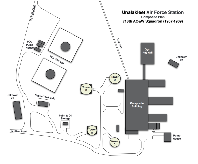
Unalakleet Air Force Station (1958-1969) - A Cold War U.S. Air Force Station, part of the Alaska AC&W Radar Network. Located on the Norton Sound of the Bering Sea coast about 400 miles northwest of Anchorage and 150 miles southeast of Nome. Initially functioned as a Ground Control Intercept (GCI) radar site, with a Permanent System ID of F-20. Later redesignated a surveillance site. Closed in 1969. HistoryIn 1955, a $3,087,046 construction contract for Unalakleet AFS was awarded to Sam Bergstrom of Tacoma, Washington. Unalakleet AFS became an operational GCI station in June 1958 manned by the 718th AC&W Squadron. The 718th had been activated in April 1957 to operate and maintain the site. Initial equipment included a FPS-8 search radar and an FPS-4 height-finder radar. In 1962 the FPS-8 search radar was changed out for a FPS-20A search radar and at some point, an FPS-6 replaced the FPS-4. Aircraft track data from these radars was manually plotted on plotting boards and passed to a Manual Direction Center on voice and teletype circuits. In 1965 the FYQ-9 Semiautomatic Data Processing and Display System was implemented on Alaska AC&W radar sites automating the passing of track data to the direction centers. The result was reduced manpower requirements and increased efficiency. In June 1969 the site ceased radar operations. The 718th AC&W Squadron was deactivated in October 1969. Physical PlantThe Unalakleet AC&W site was constructed as one of the second phase standardized Alaska AC&W site designs. This was not a split site operation and facilities included a large two-story, wood-frame composite building, a second two-story wood-frame building, two concrete buildings, a wood-frame & concrete building, and eventually four radar towers. A small commercial airstrip provided facilities for fixed wing aircraft and helicopters. The original plan called for some nine buildings. No family housing was provided as this was considered a remote unaccompanied tour (1 year). The Unalakleet was not as isolated as many of the Alaska AC&W sites. Shuttle runs operated between the site and the town of Unalakleet. Unalakleet then had a population of about 500 but drew fishermen from all over Alaska and the lower 48 during the fishing season. Alaska Airlines had daily service and carried mail for the site. Annual bulk resupply shipments to Unalakleet AFS were sealifted during the summer months under the Mona Lisa and later the Cool Barge programs. Airlift of supplies, mail and personnel was available year-round, weather permitting.
Air-Ground (A-G) CommunicationsSeparate radio facilities housed the radio transmitter and receiver equipment for communicating with aircraft. Access to one of the sites from the main site was by a steep roadway or a 7,400-foot aerial tram. A TACAN Navigational aid was located down by the airstrip. North River White Alice Communications SiteAfter HF radio systems proved inadequate for command and control communications, the Air Force implemented the White Alice Communications System (WACS). This was a system of tropospheric scatter and microwave radio relay sites constructed during the mid-1950s to provide reliable communications to Alaska Air Command (AAC) AC&W system. The North River WACS site was activated on 13 Sep 1957. This WACS site was a combination tropo/microwave station with links to Granite Mountain WACS, Kalakaket Creek WACS and to Unalakleet AFS. The site was built for a negotiated price of $3,000,000. Although the North River WACS site was considered collocated with Unalakleet AFS the WACS itself was located about 9 miles southeast of the radar site, along the North bank of the North River on the opposite bank from the Air Force Station. River flooding would periodically cut off the two sites and probably necessitated the microwave link between them. Structures on the WACS included a one-story 6,720 square-foot composite operations building, a 12 person dormitory, a Butler-type steel hut, four billboard tropo antennas, and the microwave tower. The specific links from North River WACS (KNR) as/of July 1977 were:
The North River WACS site was inactivated in 1978 and abandoned.
Current StatusAll of the old AC&W site buildings have been demolished. The site has also had an environmental remediation project that has further erased signs of the old AC&W site and the White Alice tropo site.
See Also: Sources:
Links:
Visited: No
|
