Redoubt 4 - West Point: Difference between revisions
Pidorast45 (talk | contribs) m Text replace - "== ReplaceText History ==" to "== History ==" |
Bot: Automated import of articles *** existing text overwritten *** |
||
| (4 intermediate revisions by the same user not shown) | |||
| Line 1: | Line 1: | ||
{{PageHeader|Redoubt 4 - West Point}} | |||
{{PageHeader}} | '''Redoubt 4 - West Point''' (1779-1783) - A [[Revolutionary War]] Redoubt established in 1779 on the present day military reservation of the [[United States Military Academy]] in Orange County, New York. Abandoned at the end of the war in 1783. | ||
''' | <gallery> | ||
File:WP Redoubt 4 - 23.jpg|Redoubt 4 Marker Stone | |||
File:WP Redoubt 4 - 17.jpg|Redoubt 4 Northwest Angle Magazine Location | |||
File:WP Redoubt 4 - 05.jpg|Redoubt 4 Eastern Overlook View of West Point with Fort Putnam Below | |||
File:WP Redoubt 4 - 16.jpg|Redoubt 4 Western Reentrant Angle | |||
</gallery> | |||
== History == | == History == | ||
{{FortressWestPoint}} | {{FortressWestPoint}} | ||
Initially designed as a classic hexagonal redoubt by Colonel [[Thaddeus Kosciusko]] but built out with an inverted angle facing west toward the path of enemy approach. The northeast and southeast walls each contained a single embrasure and two 6-pounder cannon were placed at these positions. Both of the cannons had a field of fire down on the West Point Plain for support of [[Fort Putnam (1)|Fort Putnam]] below. | Initially designed as a classic hexagonal redoubt by Colonel [[Thaddeus Kosciusko]] but built out with an inverted angle facing west toward the path of enemy approach. The northeast and southeast walls each contained a single embrasure and two 6-pounder cannon were placed at these positions. Both of the cannons had a field of fire down on the West Point Plain for support of [[Fort Putnam (New York 1)|Fort Putnam]] below. | ||
Described by Major General [[Benedict Arnold]] on 25 Sept 1780: “... a wooden work about ten feet high and four or five feet thick, the west side faced with a stone wall 8 feet high and four thick. No bomb proof, two six pounders, a slight abbatis, a commanding piece of ground 500 yards west.” It was designed to be manned by some 223 soldiers. | Described by Major General [[Benedict Arnold]] on 25 Sept 1780: “... a wooden work about ten feet high and four or five feet thick, the west side faced with a stone wall 8 feet high and four thick. No bomb proof, two six pounders, a slight abbatis, a commanding piece of ground 500 yards west.” It was designed to be manned by some 223 soldiers. | ||
| Line 28: | Line 24: | ||
Stabilized remains on the military reservation of the [[United States Military Academy]], Orange County, New York. Site access via dirt road off of Hamilton Street. Active military installation, access may be limited. | Stabilized remains on the military reservation of the [[United States Military Academy]], Orange County, New York. Site access via dirt road off of Hamilton Street. Active military installation, access may be limited. | ||
---- | ---- | ||
{ | {{#display_map: | ||
41.39000,-73.9727778~ GNIS Redoubt 4 - West Point; | |||
41.390197,-73.972659~ Redoubt 4 - West Point }} | |||
{{Location|[[United States Military Academy]], West Point, Orange County, New York.|41.39000|-73.9727778|810}} | |||
'''See Also:''' | '''See Also:''' | ||
| Line 62: | Line 49: | ||
--> | --> | ||
<!-- [[Category:New York]] --> | |||
[[Category:New York | |||
[[Category:New York Forts]] | [[Category:New York Forts]] | ||
[[Category:New York Orange County]] | <!-- [[Category:New York Orange County]] --> | ||
[[Category:2013 Research Trip]] | [[Category:2013 Research Trip]] | ||
[[Category:Starter Page]] | [[Category:Starter Page]] | ||
[[Category:Revolutionary War Forts]] | <!-- [[Category:Revolutionary War Forts]] --> | ||
[[Category:Fortress West Point]] | [[Category:Fortress West Point]] | ||
[[Category:Revolutionary War]] | |||
{{PageFooter}} | |||
Latest revision as of 16:05, 16 August 2026
Redoubt 4 - West Point (1779-1783) - A Revolutionary War Redoubt established in 1779 on the present day military reservation of the United States Military Academy in Orange County, New York. Abandoned at the end of the war in 1783.
-
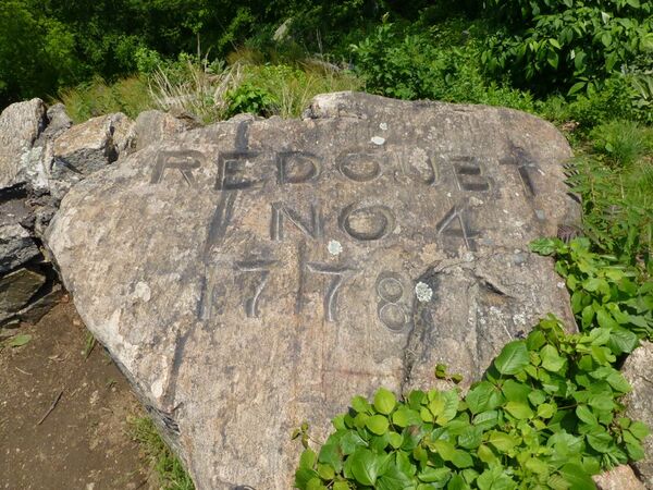 Redoubt 4 Marker Stone
 -
 Redoubt 4 Northwest Angle Magazine Location
 -
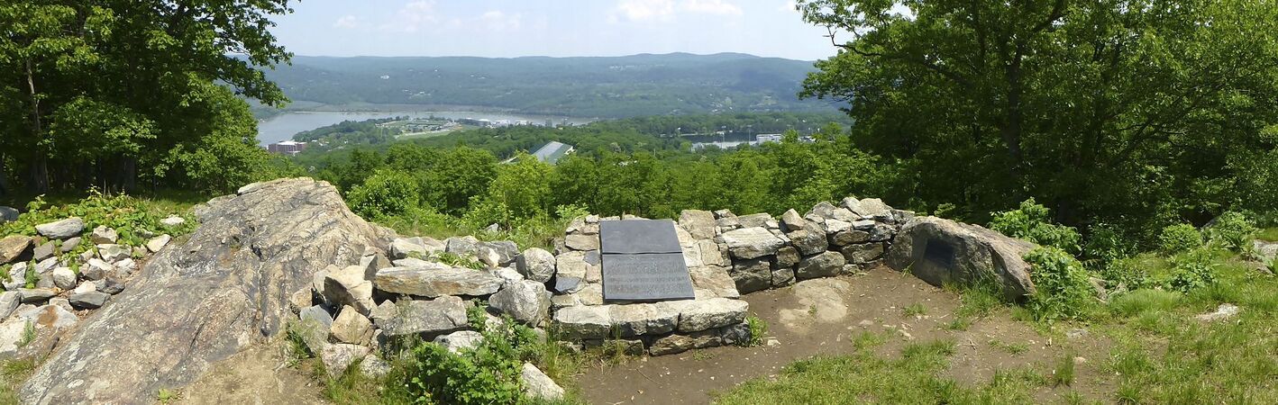 Redoubt 4 Eastern Overlook View of West Point with Fort Putnam Below
 -
 Redoubt 4 Western Reentrant Angle


History
Part of Fortress West Point.
Initially designed as a classic hexagonal redoubt by Colonel Thaddeus Kosciusko but built out with an inverted angle facing west toward the path of enemy approach. The northeast and southeast walls each contained a single embrasure and two 6-pounder cannon were placed at these positions. Both of the cannons had a field of fire down on the West Point Plain for support of Fort Putnam below.
Described by Major General Benedict Arnold on 25 Sept 1780: “... a wooden work about ten feet high and four or five feet thick, the west side faced with a stone wall 8 feet high and four thick. No bomb proof, two six pounders, a slight abbatis, a commanding piece of ground 500 yards west.” It was designed to be manned by some 223 soldiers.
-
 Redoubt 4 Plaques
 -
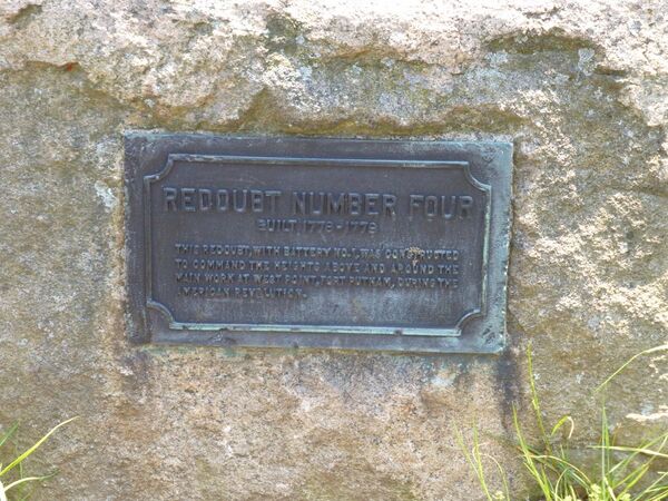 Redoubt 4 Marker
 -
 Redoubt 4 Steps
 -
 Redoubt 4 Southeast Gun position
 -
 Redoubt 4 Steep South Approach
 -
 Redoubt 4 Reentrant Angle and Ditch


Current Status
Stabilized remains on the military reservation of the United States Military Academy, Orange County, New York. Site access via dirt road off of Hamilton Street. Active military installation, access may be limited.
Location:
United States Military Academy, West Point, Orange County, New York.
Lat: 41.39° Long: -73.973° Elevation: 810'
Bing, Google,
OldMapsOnline,
USGS, OHM
See Also:
Sources:
- Roberts, Robert B., Encyclopedia of Historic Forts: The Military, Pioneer, and Trading Posts of the United States, Macmillan, New York, 1988, 10th printing, ISBN 0-02-926880-X, page 591.
- USGS Geographic Names Information System (GNIS) Database Entry: 2091613.
- Cubbison, Douglas R., Historic Structures Report: The Redoubts of West Point, U.S. Military Academy, West Point, New York, January 2004, pdf, 33 pages + appendix, illustrated, page 30-31.
- West Point Fortifications Staff Ride Note Cards, 3rd ed, USMA History Department, January 1994 changed 1998 and 2008, Pdf, 82 pages, page 55-56.
Links:
Related: 2013 Forts Visited, Benedict Arnold, Fort Putnam, Fortress West Point, Revolutionary War, West Point Portal,