Battery Park Redoubt: Difference between revisions
No edit summary |
Bot: Automated import of articles *** existing text overwritten *** |
||
| Line 1: | Line 1: | ||
{{PageHeader}} | {{PageHeader}} | ||
'''Battery Park Redoubt''' (1813-1817) - A [[War of 1812]] Fortification established in 1813 in Burlington, Chittenden County, Vermont. Abandoned in 1817. Also known as [[Camp Burlington]] | |||
<gallery> | |||
File:Battery Park Display Cannon.jpeg|Battery Park Display Cannon. | |||
File:Battery Park Marker.jpeg|Battery Park Marker. | |||
File:Battery Park Viewpoint.jpeg|Battery Park Viewpoint with Marker, Readerboard and Display Cannon. | |||
</gallery> | |||
== History == | == History == | ||
| Line 25: | Line 21: | ||
Located at the Battery Park entrance is a plaque commemorating the battery. At an overlook in the park is a roadside-style marker along with a readerboard that details the camp and the battle. A display cannon is mounted at this same location. (visited in 2012) | Located at the Battery Park entrance is a plaque commemorating the battery. At an overlook in the park is a roadside-style marker along with a readerboard that details the camp and the battle. A display cannon is mounted at this same location. (visited in 2012) | ||
---- | ---- | ||
{ | {{#display_map: | ||
44.480593,-73.219375~ Battery Park Redoubt }} | |||
{{Location|Burlington, Chittenden County, Vermont.|44.480593|-73.219375|200}} | |||
<br> | <br> | ||
'''GPS Locations:''' | '''GPS Locations:''' | ||
{{GPSLocation|Battery Park|44.480593|-73.219375}} | |||
{{GPSLocation|Markers & Cannon Location|44.480803|-73.220708}} | |||
'''See Also:''' | '''See Also:''' | ||
| Line 58: | Line 44: | ||
__NOTOC__ | __NOTOC__ | ||
{{DEFAULTSORT:Battery Park Redoubt}} | {{DEFAULTSORT:Battery Park Redoubt}} | ||
| Line 65: | Line 50: | ||
[[Category:Vermont Forts]] | [[Category:Vermont Forts]] | ||
[[Category:Vermont Chittenden County]] | [[Category:Vermont Chittenden County]] | ||
[[Category:2012 Research Trip]] | [[Category:2012 Research Trip]] | ||
[[Category:Starter Page]] | [[Category:Starter Page]] | ||
[[Category:War of 1812 Forts]] | [[Category:War of 1812 Forts]] | ||
Revision as of 04:57, 12 August 2026
Battery Park Redoubt (1813-1817) - A War of 1812 Fortification established in 1813 in Burlington, Chittenden County, Vermont. Abandoned in 1817. Also known as Camp Burlington
-
 Battery Park Display Cannon.
 -
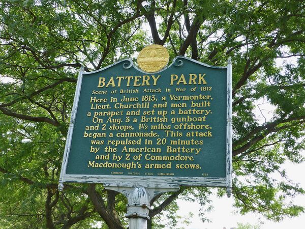 Battery Park Marker.
 -
 Battery Park Viewpoint with Marker, Readerboard and Display Cannon.


History

During the War of 1812, Battery Park at Burlington, Vermont was the site of a military encampment for some 4,000 American troops. A sketch of what the camp may have looked like is displayed on a readerboard at the park overlook. The sketch depicts a number of buildings, the largest being a two-story hospital with numerous officer's quarters and enlisted barracks buildings grouped around a central parade. A central magazine building is shown.

In June 1813 a Thirteen gun battery was built behind a long parapet overlooking Lake Champlain. The battery was about 100' above the lake and had a clear view of the lake approach to Burlington.
On 3 Aug 1813, a British gunboat and two armed sloops began a bombardment of Burlington's lake shoreline. The 13 gun battery, aided by two armed scows under Captain Thomas Macdonough's of the Lake Champlain navy, repulsed the attack in about 20 minutes.
Current Status

Located at the Battery Park entrance is a plaque commemorating the battery. At an overlook in the park is a roadside-style marker along with a readerboard that details the camp and the battle. A display cannon is mounted at this same location. (visited in 2012)
Location:
Burlington, Chittenden County, Vermont.
Lat: 44.481° Long: -73.219° Elevation: 200'
Bing, Google,
OldMapsOnline,
USGS, OHM
GPS Locations:
44.480593, -73.219375
44.480803, -73.220708
See Also:
Sources:
- Roberts, Robert B., Encyclopedia of Historic Forts: The Military, Pioneer, and Trading Posts of the United States, Macmillan, New York, 1988, 10th printing, ISBN 0-02-926880-X, page 797
Links:
- North American Forts - Burlington Cantonment
- Wikipedia - Battery Park (Burlington, Vermont)
- Burlington, Vermont Early 20th-century Postcard Views
Fortification ID:
- VT0000 - Battery Park Redoubt