Fort Raglan: Difference between revisions
Bot: Automated import of articles *** existing text overwritten *** |
Bot: Automated import of articles *** existing text overwritten *** |
||
| Line 41: | Line 41: | ||
[[Category:Washington]] | <!-- [[Category:Washington]] --> | ||
[[Category:Washington Forts]] | [[Category:Washington Forts]] | ||
[[Category:Washington Thurston County]] | <!-- [[Category:Washington Thurston County]] --> | ||
[[Category:Starter Page]] | [[Category:Starter Page]] | ||
[[Category:Washington Blockhouses]] | [[Category:Washington Blockhouses]] | ||
{{PageFooter}} | {{PageFooter}} | ||
Latest revision as of 15:28, 16 August 2026
Fort Raglan (1855-1856) - A Yakima War Fort established in 1855 in the present-day Nisqually National Wildlife Refuge, Thurston County, Washington. Reportedly named Fort Raglan after the British commander Lord Raglan, who ordered the Charge of the Light Brigade at the Battle of Balaclava in October 1854. The blockhouse was abandoned as a fortification in 1856 as hostilities moved further east.
-
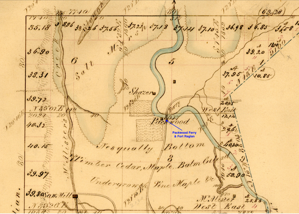 Annotated 1853 (prewar) Survey Map of the Area Around Packard's Ferry and the Future Site of Fort Raglan

History
Established in 1855 by Washington Territorial Volunteers who built a blockhouse located on the Nisqually River at Packard's Ferry on the Joel Myers land claim. The blockhouse guarded the ferry to keep the route open between the territorial capital at Olympia and Fort Steilacoom.
This was a log house (some said a barn), very strongly built with a stockade, that stood on a sand spit, on the south side of the Nisqually River.
Abandoned as a fortification in 1856 as hostilities moved further east but the structure remained standing for a number of years.
Current Status
Archeological remains only, site tentatively identified by survey and land claim maps and by some artifact recovery. At least two options for the location of the fort exist, changes in the river channel make it difficult to pinpoint the site. Option two seems more likely.
Location: In Nisqually National Wildlife Refuge,
Thurston County, Washington.
Lat: 47.07331 Long: -122.70681 Bing, Google
GPS Locations:
47.073310, -122.706810
47.068635, -122.70810
See Also:
Sources:
Links: `
- North American Forts - Fort Raglan
- Access Genealogy - Fort Raglan
- Fort Raglan
- Thurston County Historical Journals - Fort Raglan
Fortification ID:
- WA0269 - Fort Raglan