Battery 155 - Calcasieu Pass
|
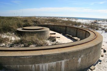
Battery 155 - Calcasieu Pass (1943-1944) - Battery 155 - Calcasieu Pass was a temporary, World War II, 155mm coastal gun battery on Panama mounts. Located on Calcasieu Pass Military Reservation, Cameron Parish, Louisiana. Battery construction started 15 Nov 1942, was completed 13 Mar 1943 and transferred to the Coast Artillery for use 9 Sep 1943 at a cost of $32,817.22. Deactivated in 1944. World War IIPart of the Temporary Harbor Defense of Calcasieu Pass, Louisiana. Originally built as a temporary World War II coastal gun battery with two 155mm M1918 rapid fire guns mounted on M1917 Mobile Carriages emplaced on circular Panama mounts. This battery was constructed at Calcasieu Pass between November 1942 to March 1943 on land that was soggy enough that all the components had to be constructed on pilings. The two Panama mounts, the four timber magazines, the two base end stations, the two searchlight platforms and the combined BC station/Plotting room/HECP were all built on pilings. The remainder of the military reservation was not constructed and the reservation was never activated. In September 1943 the troops were withdrawn and reservation was declared surplus in December 1944.

Current StatusDestroyed, no period guns or mounts in place.
Sources:
Links: Visited: No
| ||||||||||||||||||||||||||||||||||||||||||||

