Fort Branch (2): Difference between revisions
John Stanton (talk | contribs) No edit summary |
John Stanton (talk | contribs) m Text replace - "width="500"" to "width="-500" height="-500"" |
||
| (13 intermediate revisions by the same user not shown) | |||
| Line 1: | Line 1: | ||
{{PageHeader}} | {{PageHeader}} | ||
{{SocialNetworks}} | {{SocialNetworks}} | ||
'''{{PAGENAME}}''' (1862-1865) - A Confederate earthworks fort first established in 1862, during the [[U.S. Civil War]], in Martin County, North Carolina. Named for Confederate Brigadier General [[Lawrence O. Branch|Lawrence O’Brian Branch]], who was killed at Sharpsburg, 17 Sep 1862. The fort was abandoned in April 1865 at the war's end. | |||
'''{{PAGENAME}}''' (1862-1865) - A Confederate | |||
{|{{FWpicframe}} | {|{{FWpicframe}} | ||
|- valign="top" | |- valign="top" | ||
| Line 11: | Line 9: | ||
|colspan="2"|[[File:Reconstructed Cannon Position.jpg|795px|thumb|center|Fort Branch Reconstructed Cannon Position - Rifled 32-Pounder.]] | |colspan="2"|[[File:Reconstructed Cannon Position.jpg|795px|thumb|center|Fort Branch Reconstructed Cannon Position - Rifled 32-Pounder.]] | ||
|} | |} | ||
== History == | == History == | ||
Fort Branch was located on a | Fort Branch was located on a 65' bluff at Rainbow Banks on the Roanoke River. The fort was designed to help block Union gunboat access up the Roanoke River and to protect a critical railroad trestle. | ||
The original fortification was built in February 1862 with an upper battery of three guns and a lower battery of two guns by a Confederate engineer, Captain [[Richard K. Meade]]. Part of his original fortification was destroyed by a Union raid but a stronger eleven gun fortification was completed in two months and the guns mounted by 9 Feb 1863. | The original fortification was built in February 1862 with an upper battery of three guns and a lower battery of two guns by a Confederate engineer, Captain [[Richard K. Meade]]. Part of his original fortification was destroyed by a Union raid but a stronger eleven gun fortification was completed in two months and the guns mounted by 9 Feb 1863. | ||
| Line 23: | Line 20: | ||
{{Clr}} | {{Clr}} | ||
== Current Status == | == Current Status == | ||
[[File:Fort Branch Bridge.jpg|thumb|left|250px|Fort Branch Entrance Bridge.]] | |||
[[File:Fort Branch Earthworks.jpg||thumb|right|250px|Fort Branch Exterior Earthworks View.]] | |||
[[File:Fort Branch Recovered Cannons.jpg|thumb|left|250px|Fort Branch Four Recovered Cannons.]] | [[File:Fort Branch Recovered Cannons.jpg|thumb|left|250px|Fort Branch Four Recovered Cannons.]] | ||
[[File:Fort Branch Recovered Carriage.jpg|thumb|right|250px|Fort Branch Recovered Carriage.]] | [[File:Fort Branch Recovered Carriage.jpg|thumb|right|250px|Fort Branch Recovered Carriage.]] | ||
Privately owned but open to the public, administered by the Fort Branch | [[File:Fort Branch 1850s Cabin.jpg|thumb|left|250px|Fort Branch 1850s Cabin.]] | ||
[[File:Fort Branch Gunboat Models.jpg|thumb|right|250px|Fort Branch Gunboat Models.]] | |||
Must See! Privately owned but open to the public, administered by the Fort Branch Historical Society, Martin County, North Carolina. The site has been partially restored/recreated. Eight of the original twelve cannons and their carriages were recovered from the Roanoke River and are on display in the visitor center/museum. | |||
A 25 stop walking tour is provided with numbered markers at each location. The markers are referenced to a handout and a facsimile of an 1861 plan of the fort. Adjacent to the fort is a replica of what the winter quarters for the troops may have looked like. The visitor center/museum is a gold mine of information and artifacts including the recovered guns and carriages. Don't miss the collection of miniature Confederate gunboat models. Next to the visitor center/museum is a restored 1850s period cabin. | |||
The site is staffed by volunteers from the [http://www.fortbranchcivilwarsite.com Fort Branch Historical Society] and is currently open to the public beginning on the first Saturday in April through their re-enactment weekend in November. The hours of operation are from 1:30 to 5:30 pm on those Saturdays. | |||
A roadside marker is located on NC 125 at the intersection with Fort Branch Road (SR 1416). The site itself is well marked with a sign and a reader board at the entrance. The road leads directly to the visitor center/museum. | |||
{{Clr}} | {{Clr}} | ||
---- | ---- | ||
{| | {| | ||
| | | | ||
<googlemap version="0.9" lat="35.928537" lon="-77.170705" zoom="17" width="500" scale="yes" overview="yes" controls="large" icons="http://www.fortwiki.com/mapicons/icon{label}.png"> | <googlemap version="0.9" lat="35.928537" lon="-77.170705" zoom="17" width="-500" height="-500" scale="yes" overview="yes" controls="large" icons="http://www.fortwiki.com/mapicons/icon{label}.png"> | ||
(F) 35. | (F) 35.92909, -77.17044, Fort Branch (2) | ||
(1862-1865) | (1862-1865) | ||
(M) 35. | (M) 35.92767, -77.20308, Fort Branch Marker | ||
(E) 35.92703, -77.17136, Entrance | |||
</googlemap> | </googlemap> | ||
|valign="top"| | |valign="top"| | ||
'''Location:''' | '''Location:''' Entrance located at 2883 Fort Branch Rd. Oak City NC (35.92703, -77.17136). Zoom out to see marker location. | ||
{{Mapit-US-cityscale|35. | {{Mapit-US-cityscale|35.92909|-77.17044}} | ||
* Elevation: | * Elevation: 65' | ||
|} | |} | ||
| Line 49: | Line 56: | ||
'''Links:''' | '''Links:''' | ||
* [http://www.northamericanforts.com North American Forts - Fort Branch (2)] | * [http://www.northamericanforts.com North American Forts - Fort Branch (2)] | ||
* [http://www.fortbranchcivilwarsite.com/ Fort Branch | * [http://www.fortbranchcivilwarsite.com/ Fort Branch Historical Society Website] | ||
* [http://www.civilwaralbum.com/misc8/fort_branch1.htm Civil War Album - Fort Branch] | * [http://www.civilwaralbum.com/misc8/fort_branch1.htm Civil War Album - Fort Branch] | ||
{{Visited|23 Mar 2018}} | {{Visited|23 Mar 2018}} | ||
<!--2840 25 Mar 2018--> | |||
__NOTOC__ | __NOTOC__ | ||
| Line 66: | Line 73: | ||
[[Category:2018 Research Trip]] | [[Category:2018 Research Trip]] | ||
[[Category:U.S. Civil War Forts]] | [[Category:U.S. Civil War Forts]] | ||
[[Category:Must See]] | |||
Latest revision as of 20:45, 7 January 2019
|
Fort Branch (2) (1862-1865) - A Confederate earthworks fort first established in 1862, during the U.S. Civil War, in Martin County, North Carolina. Named for Confederate Brigadier General Lawrence O’Brian Branch, who was killed at Sharpsburg, 17 Sep 1862. The fort was abandoned in April 1865 at the war's end.
HistoryFort Branch was located on a 65' bluff at Rainbow Banks on the Roanoke River. The fort was designed to help block Union gunboat access up the Roanoke River and to protect a critical railroad trestle. The original fortification was built in February 1862 with an upper battery of three guns and a lower battery of two guns by a Confederate engineer, Captain Richard K. Meade. Part of his original fortification was destroyed by a Union raid but a stronger eleven gun fortification was completed in two months and the guns mounted by 9 Feb 1863. The fort was evacuated on 10 Apr 1865, a day after General Lee surrendered at Appomattox. The magazine was blown up and the remaining ammunition was dumped into the Fort's well and the guns were dumped into the Roanoke River. 
Current Status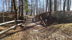 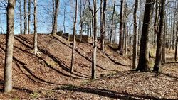 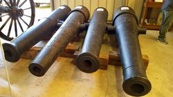 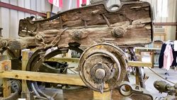 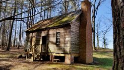 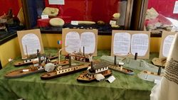 Must See! Privately owned but open to the public, administered by the Fort Branch Historical Society, Martin County, North Carolina. The site has been partially restored/recreated. Eight of the original twelve cannons and their carriages were recovered from the Roanoke River and are on display in the visitor center/museum. A 25 stop walking tour is provided with numbered markers at each location. The markers are referenced to a handout and a facsimile of an 1861 plan of the fort. Adjacent to the fort is a replica of what the winter quarters for the troops may have looked like. The visitor center/museum is a gold mine of information and artifacts including the recovered guns and carriages. Don't miss the collection of miniature Confederate gunboat models. Next to the visitor center/museum is a restored 1850s period cabin. The site is staffed by volunteers from the Fort Branch Historical Society and is currently open to the public beginning on the first Saturday in April through their re-enactment weekend in November. The hours of operation are from 1:30 to 5:30 pm on those Saturdays. A roadside marker is located on NC 125 at the intersection with Fort Branch Road (SR 1416). The site itself is well marked with a sign and a reader board at the entrance. The road leads directly to the visitor center/museum.
Sources:
Links:
Visited: 23 Mar 2018
| ||||||


