Fort Wade: Difference between revisions
John Stanton (talk | contribs) No edit summary |
John Stanton (talk | contribs) No edit summary |
||
| (7 intermediate revisions by the same user not shown) | |||
| Line 1: | Line 1: | ||
{{PageHeader}} | |||
{{SocialNetworks}} | {{SocialNetworks}} | ||
'''{{PAGENAME}}''' (1863-1863) - First established in March 1863 by Confederate forces during the [[U.S. Civil War]]. Named after Col. [[William Wade]] who was killed during the 29 Apr 1863 attack on the fort. Abandoned in 1863. | '''{{PAGENAME}}''' (1863-1863) - First established in March 1863 by Confederate forces during the [[U.S. Civil War]]. Named after Col. [[William Wade]] who was killed during the 29 Apr 1863 attack on the fort. Abandoned in 1863. | ||
{{Clr}} | {{Clr}} | ||
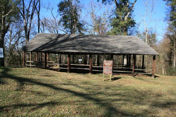
[[Image:Fort Wade Magazine GGMM - 01.jpg| | [[Image:Fort Wade Magazine GGMM - 01.jpg|350px|thumb|left|Fort Wade Magazine Ruins.]] | ||
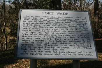
[[Image:Fort Wade Signs - 5.jpg| | [[Image:Fort Wade Signs - 5.jpg|350px|thumb|right|Fort Wade Sign.]] | ||
{{Clr}} | {{Clr}} | ||
== | == History == | ||
Part of the Confederate defense of the town of Grand Gulf during the Union effort to capture Vicksburg, Mississippi. The fort consisted of earthen works shielding four heavy rifle positions. | Part of the Confederate defense of the town of Grand Gulf during the Union effort to capture Vicksburg, Mississippi. The fort consisted of earthen works shielding four heavy rifle positions. | ||
| Line 11: | Line 12: | ||
== Current Status == | == Current Status == | ||
Part of Grand Gulf Military Monument. No period guns or mounts in place. The earthworks are visible and the destroyed magazine is under protective cover. | Part of Grand Gulf Military Monument. No period guns or mounts in place. The earthworks are visible and the destroyed magazine is under protective cover. | ||
---- | |||
{| | {| | ||
| | | | ||
<googlemap version="0.9" lat="32.031677" lon="-91.052215" zoom="17" width="500" scale="yes" overview="yes" controls="large" icons="http://www.fortwiki.com/mapicons/icon{label}.png"> | <googlemap version="0.9" lat="32.031677" lon="-91.052215" zoom="17" width="-500" height="-500" scale="yes" overview="yes" controls="large" icons="http://www.fortwiki.com/mapicons/icon{label}.png"> | ||
(F) 32.031677, -91.052215 | (F) 32.031677, -91.052215, Fort Wade | ||
Fort Wade | (1863-1863) | ||
</googlemap> | </googlemap> | ||
|valign="top"| | |valign="top"| | ||
| Line 30: | Line 33: | ||
{{Visited|5 Dec 2009}} | {{Visited|5 Dec 2009}} | ||
== | == Picture Gallery == | ||
<gallery> | <gallery> | ||
Image:Fort Wade Mortar - 1.jpg|Gunboat Mortar | Image:Fort Wade Mortar - 1.jpg|Gunboat Mortar | ||
Image:Fort Wade Magazine GGMM - 02.jpg|Magazine Ruins | |||
Image:Fort Wade Site - 2.jpg|Fort Site from below | |||
Image:Fort Wade Site - 5.jpg|Fort Site from above | |||
</gallery> | </gallery> | ||
__NOTOC__ | __NOTOC__ | ||
{{PageFooter}} | |||
{{DEFAULTSORT:Wade}} | {{DEFAULTSORT:Wade}} | ||
[[Category:All]] | [[Category:All]] | ||
Latest revision as of 14:09, 3 October 2020
|
Fort Wade (1863-1863) - First established in March 1863 by Confederate forces during the U.S. Civil War. Named after Col. William Wade who was killed during the 29 Apr 1863 attack on the fort. Abandoned in 1863.
 
HistoryPart of the Confederate defense of the town of Grand Gulf during the Union effort to capture Vicksburg, Mississippi. The fort consisted of earthen works shielding four heavy rifle positions. Armament during the April 28-29 battle consisted of two 20 pounder Parrott rifles and two 32 pounder rifles. One of the Parrott riles burst and two 32 pounders were dismounted and the parapet destroyed. Col Wade was decapitated in the fight and the fort was silenced by fire from five heavy Union gunboats. Current StatusPart of Grand Gulf Military Monument. No period guns or mounts in place. The earthworks are visible and the destroyed magazine is under protective cover.
Sources:
Links: Visited: 5 Dec 2009 Picture Gallery
|


