Medicine Hat NWMP Barracks: Difference between revisions
Jump to navigation
Jump to search
John Stanton (talk | contribs) m Text replace - "==ReplaceText Picture Gallery== {| cellspacing="5" width="800px" border="1" cellpadding="5" | |- valign="top" |width="33%" class="MainPageBG" style="border: 1px solid #c6c9ff; color: #000; background-color: #f0f0ff"| '''Click on the pictu |
Bill Thayer (talk | contribs) m Text replace - "== ReplaceText History ==" to "== History ==" |
||
| (3 intermediate revisions by 2 users not shown) | |||
| Line 4: | Line 4: | ||
{|{{FWpicframe}} | {|{{FWpicframe}} | ||
|- valign="top" | |- valign="top" | ||
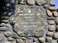
|width="50%"|[[File:Medicine Hat NWMP Bks - 22.jpg| | |width="50%"|[[File:Medicine Hat NWMP Bks - 22.jpg|350px|thumb|left|Medicine Hat NWMP Barracks Park Sign]] | ||
|width="50%"|[[File:Medicine Hat NWMP Bks - 14.jpg| | |width="50%"|[[File:Medicine Hat NWMP Bks - 14.jpg|350px|thumb|right|Medicine Hat NWMP Barracks Cairn on the Golf Course]] | ||
|- | |- | ||
|colspan="2"|[[File:Medicine Hat NWMP Bks - 13.jpg|795px|thumb|center|South Saskatchewan River from Near the Site of the Barracks]] | |colspan="2"|[[File:Medicine Hat NWMP Bks - 13.jpg|795px|thumb|center|South Saskatchewan River from Near the Site of the Barracks]] | ||
|} | |} | ||
== | == History == | ||
Established as a North West Mounted Police Barracks in 1883 on a bluff overlooking the South Saskatchewan River across from present day Medicine Hat, Alberta. The post came to have 13 buildings housing 25 men and their horses. It was located at a river crossing and had | Established as a North West Mounted Police Barracks in 1883 on a bluff overlooking the South Saskatchewan River across from present day Medicine Hat, Alberta. The post came to have 13 buildings housing 25 men and their horses. It was located at a river crossing and had its own ferry landing at what was known as Police Point. | ||
With the coming of the railroad and the growth Medicine Hat the decision was made in 1893 to move the post across the river and into the town of Medicine Hat. | With the coming of the railroad and the growth Medicine Hat the decision was made in 1893 to move the post across the river and into the town of Medicine Hat. | ||
| Line 23: | Line 23: | ||
{| | {| | ||
| | | | ||
<googlemap version="0.9" lat="50.04791" lon="-110.6564" zoom="17" width="500" scale="yes" overview="yes" controls="large" icons="http://www.fortwiki.com/mapicons/icon{label}.png"> | <googlemap version="0.9" lat="50.04791" lon="-110.6564" zoom="17" width="-500" height="-500" scale="yes" overview="yes" controls="large" icons="http://www.fortwiki.com/mapicons/icon{label}.png"> | ||
(B) 50.04791, -110.6564, Medicine Hat NWMP Barracks | (B) 50.04791, -110.6564, Medicine Hat NWMP Barracks | ||
(1883-1893) | (1883-1893) | ||


