Fort Loyal: Difference between revisions
No edit summary |
Bot: Automated import of articles *** existing text overwritten *** |
||
| (3 intermediate revisions by the same user not shown) | |||
| Line 1: | Line 1: | ||
{{PageHeader | {{PageHeader|Loyal}} | ||
'''Fort Loyal''' (1680-1690) - Established as a colonial log palisaded fort in 1680 in present day Portland, Cumberland County, Maine. Captured by the French in 1690 and destroyed. Also known as [[Fort Loyall]]. Assigned Location ID '''ME00069'''. | |||
''' | <gallery> | ||
File:Fort Loyal - 2.jpg|Fort Loyal Plaque Location | |||
File:Fort Loyal - 5.jpg|Fort Loyal Location on Portland Waterfront | |||
File:Fort Loyal Plaque.jpg|Fort Loyal Plaque | |||
</gallery> | |||
== History == | == History == | ||
Established as a colonial log palisaded fort and settler refuge in 1680 and by 1890 had four blockhouses and mounted eight guns. The fort was captured by the French and their Indian allies in May 1690. The fort was under the command of Captain [[Sylvanus Davis]] who surrendered the fort on condition that the occupants be spared. The French under [[Sieur de Portneuf]] violated the agreement and all but Captain Davis and four others were massacred. The fort was burned down. | Established as a colonial log palisaded fort and settler refuge in 1680 and by 1890 had four blockhouses and mounted eight guns. The fort was captured by the French and their Indian allies in May 1690. The fort was under the command of Captain [[Sylvanus Davis]] who surrendered the fort on condition that the occupants be spared. The French under [[Sieur de Portneuf]] violated the agreement and all but Captain Davis and four others were massacred. The fort was burned down. | ||
== Current Status == | == Current Status == | ||
Plaque only on a waterfront building in Portland, Cumberland County, Maine | Plaque only on a waterfront building in Portland, Cumberland County, Maine | ||
{ | {{#display_map: | ||
43.659511,-70.248191~ Fort Loyal >(1680-1690)}} | |||
{{Location|At the waterfront end of India Street in Portland, Cumberland County, Maine.|43.659511|-70.248191}} | |||
>(1680-1690) | |||
| | |||
'''Sources:''' | '''Sources:''' | ||
| Line 36: | Line 24: | ||
<!-- [[Category:Maine]] --> | |||
[[Category:Maine | |||
[[Category:Maine Forts]] | [[Category:Maine Forts]] | ||
[[Category:Maine Cumberland County]] | <!-- [[Category:Maine Cumberland County]] --> | ||
[[Category:Starter Page]] | [[Category:Starter Page]] | ||
[[Category:2012 Research Trip]] | [[Category:2012 Research Trip]] | ||
[[Category:Colonial Forts]] | [[Category:Colonial Forts]] | ||
[[Category:Harbor Defense of Portland]] | [[Category:Harbor Defense of Portland]] | ||
{{PageFooter}} | |||
Latest revision as of 15:16, 16 August 2026
Fort Loyal (1680-1690) - Established as a colonial log palisaded fort in 1680 in present day Portland, Cumberland County, Maine. Captured by the French in 1690 and destroyed. Also known as Fort Loyall. Assigned Location ID ME00069.
-
 Fort Loyal Plaque Location
 -
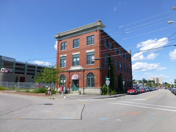 Fort Loyal Location on Portland Waterfront
 -
 Fort Loyal Plaque


History
Established as a colonial log palisaded fort and settler refuge in 1680 and by 1890 had four blockhouses and mounted eight guns. The fort was captured by the French and their Indian allies in May 1690. The fort was under the command of Captain Sylvanus Davis who surrendered the fort on condition that the occupants be spared. The French under Sieur de Portneuf violated the agreement and all but Captain Davis and four others were massacred. The fort was burned down.
Current Status
Plaque only on a waterfront building in Portland, Cumberland County, Maine
Location: At the waterfront end of India Street in Portland, Cumberland County, Maine.
Lat: 43.659511 Long: -70.248191 Bing, Google
Sources:
- Roberts, Robert B., Encyclopedia of Historic Forts: The Military, Pioneer, and Trading Posts of the United States, Macmillan, New York, 1988, 10th printing, ISBN 0-02-926880-X, page 367
Links:
Location: 43.66°, -70.248° Bing, Google, OldMapsOnline, USGS, OHM
Related:
2012 New England Plan, Fort Loyall, New or Updated Forts and Camps,