Mission San Francisco de la Espada: Difference between revisions
John Stanton (talk | contribs) No edit summary |
Bill Thayer (talk | contribs) m Text replace - "== ReplaceText History ==" to "== History ==" |
||
| (20 intermediate revisions by 2 users not shown) | |||
| Line 1: | Line 1: | ||
{{SocialNetworks}} | {{SocialNetworks}} | ||
'''{{PAGENAME}}''' (1731-1824) - A fortified Spanish mission established in 1731 by Franciscan missionaries in Bexar County, Texas. Abandoned in 1824. | {{PageHeader}} | ||
'''{{PAGENAME}}''' (1731-1824) - A fortified Spanish mission established in 1731 by Franciscan missionaries in present day Bexar County, Texas. Abandoned in 1824. | |||
{|{{FWpicframe}} | {|{{FWpicframe}} | ||
|- valign="top" | |- valign="top" | ||
| Line 8: | Line 9: | ||
|colspan="2"|[[Image:Mission Espada - 03.jpg|795px|thumb|center|Mission Espada Outer Wall]] | |colspan="2"|[[Image:Mission Espada - 03.jpg|795px|thumb|center|Mission Espada Outer Wall]] | ||
|} | |} | ||
== | == History == | ||
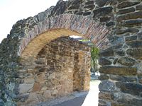
[[Image:Mission Espada Entrance - 2.jpg|thumb|left|200px|Mission Espada Entrance]] | [[Image:Mission Espada Entrance - 2.jpg|thumb|left|200px|Mission Espada Entrance]] | ||
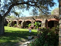
[[Image:Mission Espada - 25.jpg|thumb|left|200px|Mission Espada Residences]] | |||
The mission was initially established in east Texas as [[Mission San Francisco de los Texas]] in 1690. The mission was moved to its current location and reestablished as Mission San Francisco de la Espada on 5 Mar 1731. | |||
The mission concept included bringing friendly Indians into the mission and organizing a Christian community with the Indian leaders functioning as the leaders of the community. The priest was responsible for the religious instruction and care of the community. A limited number of soldiers were typically assigned for protection and as a deterrent to any attack by hostile Indians. A nearby presidio was established to furnish a stronger force that could respond to serious attacks on any mission and to protect ranchers and colonists in the area. The [[Presidio San Antonio de Bexar]] was established in 1718 to protect the missions, ranchers and colonists the San Antonio area. | |||
The mission was built out as walled compound with outer rock walls over two foot thick and a limited number of defendable entrances. The defenses evolved over the years to include two bastions. The exterior rock walls were further strengthened by Indian quarters built along the inside of the exterior walls. Inside the compound were the church and the priest's residence as well as a granary and workshops. | |||
The process of secularization began in 1794 and the mission lands were distributed to the remaining fifteen Indian families. The mission could not afford to equip and supply each of the families so they had to share equipment and supplies. | |||
{{Clr}} | {{Clr}} | ||
== Current Status == | == Current Status == | ||
Part of San Antonio Missions National Historical Park, Bexar County, Texas | Part of San Antonio Missions National Historical Park, Bexar County, Texas. | ||
{| | {| | ||
| | | | ||
<googlemap version="0.9" lat="29.3180148" lon="-98.4508488" zoom="17" width="500" scale="yes" overview="yes" controls="large" icons="http://www.Fortwiki.com/mapicons/icon{label}.png"> | <googlemap version="0.9" lat="29.3180148" lon="-98.4508488" zoom="17" width="-500" height="-500" scale="yes" overview="yes" controls="large" icons="http://www.Fortwiki.com/mapicons/icon{label}.png"> | ||
(F) 29.3180148, -98.4508488 | (F) 29.3180148, -98.4508488 | ||
Fort Mission San Francisco de la Espada<br>(1731-1824) | Fort Mission San Francisco de la Espada<br>(1731-1824) | ||
| Line 34: | Line 42: | ||
{{Visited|28 Nov 2011}} | {{Visited|28 Nov 2011}} | ||
__NOTOC__ | __NOTOC__ | ||
{{PageFooter}} | |||
{{DEFAULTSORT:Mission San Francisco de la Espada}} | {{DEFAULTSORT:Mission San Francisco de la Espada}} | ||
[[Category:All]] | [[Category:All]] | ||
| Line 50: | Line 55: | ||
[[Category:Starter Page]] | [[Category:Starter Page]] | ||
[[Category:2011-2012 Trip]] | [[Category:2011-2012 Trip]] | ||
[[Category:Spanish Colonial Forts]] | |||
[[Category:Texas Missions]] | |||
Latest revision as of 06:13, 23 September 2021
|
Mission San Francisco de la Espada (1731-1824) - A fortified Spanish mission established in 1731 by Franciscan missionaries in present day Bexar County, Texas. Abandoned in 1824.
History  The mission was initially established in east Texas as Mission San Francisco de los Texas in 1690. The mission was moved to its current location and reestablished as Mission San Francisco de la Espada on 5 Mar 1731. The mission concept included bringing friendly Indians into the mission and organizing a Christian community with the Indian leaders functioning as the leaders of the community. The priest was responsible for the religious instruction and care of the community. A limited number of soldiers were typically assigned for protection and as a deterrent to any attack by hostile Indians. A nearby presidio was established to furnish a stronger force that could respond to serious attacks on any mission and to protect ranchers and colonists in the area. The Presidio San Antonio de Bexar was established in 1718 to protect the missions, ranchers and colonists the San Antonio area. The mission was built out as walled compound with outer rock walls over two foot thick and a limited number of defendable entrances. The defenses evolved over the years to include two bastions. The exterior rock walls were further strengthened by Indian quarters built along the inside of the exterior walls. Inside the compound were the church and the priest's residence as well as a granary and workshops. The process of secularization began in 1794 and the mission lands were distributed to the remaining fifteen Indian families. The mission could not afford to equip and supply each of the families so they had to share equipment and supplies.
Current StatusPart of San Antonio Missions National Historical Park, Bexar County, Texas.
Sources: Links: Visited: 28 Nov 2011
| ||||||


