Fort Reading: Difference between revisions
John Stanton (talk | contribs) No edit summary |
Bill Thayer (talk | contribs) m Text replace - "== History ==" to "==History of ReplaceText==" |
||
| (18 intermediate revisions by one other user not shown) | |||
| Line 1: | Line 1: | ||
{{PageHeader}} | |||
{{SocialNetworks}} | {{SocialNetworks}} | ||
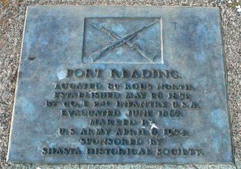
'''Fort Reading (1852-1856) (1866-1867)''' - A U.S. Army post established 26 May 1852 during the [[California Gold Rush]] by 1st Lt. [[Nelson H. Davis]], Company E, [[2nd U.S. Infantry]] and named for Major [[Pierson B. Reading]]. The garrison was withdrawn on 1 Apr 1856 and intermittently occupied until 13 Jun 1867. Abandoned on 6 Apr 1870. | |||
'''Fort Reading (1852-1856) (1866-1867)''' - | {{Clr}} | ||
== History of {{PAGENAME}} == | [[Image:Fort Reading - 02 copy.jpg|thumb|left|350px|Fort Reading Roadside Marker]] | ||
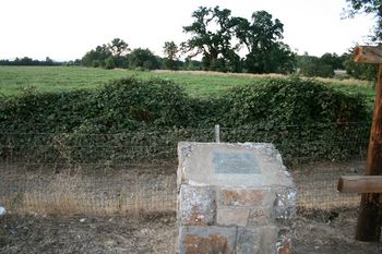
Established as a two company post on the west side of Cow Creek to protect the mining district from hostile Indians. The creek was prone to flooding when the rains came and the fort was often flooded during the rainy season. | [[Image:Fort Reading - 10.jpg|thumb|right|350px|Fort Reading Site View from Marker]] | ||
{{Clr}} | |||
==History of {{PAGENAME}}== | |||
Established as a two company post on the west side of Cow Creek during the [[California Gold Rush]] to protect the mining district from hostile Indians. The creek was prone to flooding when the rains came and the fort was often flooded during the rainy season. | |||
---- | ---- | ||
{| | {| | ||
| | | | ||
<googlemap lat="40. | <googlemap version="0.9" lat="40.476554" lon="-122.229992" zoom="17" width="-500" height="-500" scale="yes" overview="yes" controls="large" icons="http://www.fortwiki.com/mapicons/icon{label}.png"> | ||
(F) 40. | (F) 40.47655, -122.22999 | ||
Fort Reading<br>(1852-1856)<br>(1866-1867) | |||
</googlemap> | </googlemap> | ||
|valign="top"| | |valign="top"| | ||
'''Location:''' 0.6 mi E of intersection of Deschutes and Dersch Rds, 6 mi NE of Anderson, California. | '''Location:''' On Dersch road 0.6 mi E of intersection of Deschutes and Dersch Rds, 6 mi NE of Anderson, Shasta County, California. The location shown is the site of the roadside marker. | ||
{{Mapit-US-cityscale|40. | {{Mapit-US-cityscale|40.47655|-122.22999}} | ||
* Elevation: 400' | * Elevation: 400' | ||
|} | |} | ||
| Line 20: | Line 25: | ||
* {{Hart}}, page 32 | * {{Hart}}, page 32 | ||
* {{Frazer}}, page 29 | * {{Frazer}}, page 29 | ||
* {{Roberts}}, page 84 | |||
* {{Mansfield}} | |||
'''Links:''' | '''Links:''' | ||
* [http://www.northamericanforts.com/West/ca.html#reading North American Forts - Fort Reading] | |||
* [http://www.militarymuseum.org/FtReading.html California Military History] | * [http://www.militarymuseum.org/FtReading.html California Military History] | ||
* [http://www.forttours.com/pages/fortreading.asp Fort Tours] | * [http://www.forttours.com/pages/fortreading.asp Fort Tours] | ||
{{Visited| | {{Visited|4 Aug 2009}} | ||
==Picture Gallery== | ==Picture Gallery== | ||
{{PictureHead}} | {{PictureHead}} | ||
<gallery> | <gallery> | ||
Image:Fort Reading - 05.jpg|Cow Creek Bridge Near Fort Reading Location | |||
Image:Fort Reading - 06.jpg|Cow Creek Near Fort Reading Location | |||
Image:Fort Reading - 03.jpg|Fort Reading Marker | |||
</gallery> | </gallery> | ||
{{PageFooter}} | |||
__NOTOC__ | __NOTOC__ | ||
| Line 35: | Line 48: | ||
{{DEFAULTSORT:Reading}} | {{DEFAULTSORT:Reading}} | ||
[[Category:All]] | [[Category:All]] | ||
[[Category:California All]] | |||
[[Category:California Forts]] | [[Category:California Forts]] | ||
[[Category: | [[Category:California Shasta County]] | ||
[[Category:California Gold Rush Forts]] | |||
[[Category:Private Property]] | [[Category:Private Property]] | ||
[[Category:{{PAGENAME}}]] | [[Category:{{PAGENAME}}]] | ||
Latest revision as of 09:10, 17 March 2019
|
Fort Reading (1852-1856) (1866-1867) - A U.S. Army post established 26 May 1852 during the California Gold Rush by 1st Lt. Nelson H. Davis, Company E, 2nd U.S. Infantry and named for Major Pierson B. Reading. The garrison was withdrawn on 1 Apr 1856 and intermittently occupied until 13 Jun 1867. Abandoned on 6 Apr 1870.
 
History of Fort ReadingEstablished as a two company post on the west side of Cow Creek during the California Gold Rush to protect the mining district from hostile Indians. The creek was prone to flooding when the rains came and the fort was often flooded during the rainy season.
Sources:
Links: Visited: 4 Aug 2009 Picture Gallery
|


