Fort Klamath: Difference between revisions
Jump to navigation
Jump to search
John Stanton (talk | contribs) No edit summary |
John Stanton (talk | contribs) No edit summary |
||
| Line 28: | Line 28: | ||
* [http://www.1-14th.com/HistInd-FtKlamath.htm A History of Fort Klamath] | * [http://www.1-14th.com/HistInd-FtKlamath.htm A History of Fort Klamath] | ||
* [http://www.drizzle.com/~rdpayne/fclnpv74.htm Fort Klamath Museum] | * [http://www.drizzle.com/~rdpayne/fclnpv74.htm Fort Klamath Museum] | ||
{{Visited| | {{Visited|29 Jun 2008}} | ||
==Picture Gallery== | ==Picture Gallery== | ||
{{PictureHead}} | {{PictureHead}} | ||
| Line 39: | Line 38: | ||
[[Category:Oregon Forts]] | [[Category:Oregon Forts]] | ||
[[Category:Oregon All]] | [[Category:Oregon All]] | ||
[[Category:All]] | [[Category:All]] | ||
[[Category: | [[Category:Preserved]] | ||
[[Category: | [[Category:State Park]] | ||
[[Category:{{PAGENAME}}]] | [[Category:{{PAGENAME}}]] | ||
__NOTOC__ | __NOTOC__ | ||
__NOEDITSECTION__ | __NOEDITSECTION__ | ||
Revision as of 19:57, 30 June 2008
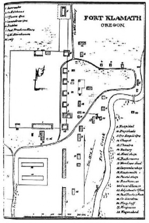
Fort Klamath (1863-1890) - Established by two companies of soldiers under Maj. Charles C Drew on 5 September 1863. Fort Klamath was an important post during Modoc, Snake and Piute wars. The majority of troops were removed in 1889 and the fort was finally left to a caretaker on 23 Jun 1890.


|
{"selectable":false,"width":"500"} |
Location: Klamath County, Oregon at a point about a mile southeast of the present community of Klamath Falls. Maps & Images Lat: 42.692341 Long: -121.972232 |
Sources:
- Hart, Herbert M., Tour Guide to Old Western Forts, Pruett Publishing Co., Boulder CO, 1980, ISBN 0-87108-568-2, page 135
- Oregon Military History, Forts-Camps-Roads
- McArthur, Lewis A. & McArthur, Lewis L., Oregon Geographic Names, Oregon Historical Society Press; 7 edition (December 2003), 1073 pages, ISBN 0875952771, ISBN 978-0875952772, page 370
Links:
- Wikipedia Article
- National Register of Historic Places added 1971 Site - #71000680
- A History of Fort Klamath
- Fort Klamath Museum
Visited: 29 Jun 2008
Picture Gallery
|
Click on the picture to see a larger version. Contribute additional pictures - the more the better! |