Category:Fort Phil Kearny: Difference between revisions
mNo edit summary |
John Stanton (talk | contribs) No edit summary |
||
| Line 6: | Line 6: | ||
[[Category:Bozeman Trail]] | [[Category:Bozeman Trail]] | ||
[[Category:Wyoming Fort Trail]] | [[Category:Wyoming Fort Trail]] | ||
[[Category:{{PAGENAME}}]] | |||
{{SocialNetworks}} | |||
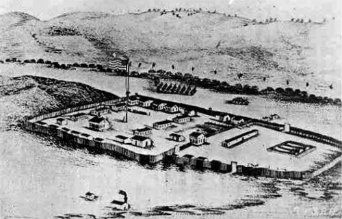
[[Image:FortPhilKearny c1867.jpg|500px|thumb|left|Fort Kearny, circa 1867]] | [[Image:FortPhilKearny c1867.jpg|500px|thumb|left|Fort Kearny, circa 1867]] | ||
'''Fort Phil Kearny (1866-1868)''' - Named for popular Union General, [[Philip Kearny]], it was established by Col. [[Henry B. Carrington]] of the [[18th U.S. Infantry]] in Jul, 1866 to protect emigrants traveling the [[Bozeman Trail]] north to the gold fields of Montana, and also to prevent intertribal warfare between Native American tribes. | '''Fort Phil Kearny (1866-1868)''' - Named for popular Union General, [[Philip Kearny]], it was established by Col. [[Henry B. Carrington]] of the [[18th U.S. Infantry]] in Jul, 1866 to protect emigrants traveling the [[Bozeman Trail]] north to the gold fields of Montana, and also to prevent intertribal warfare between Native American tribes. | ||
| Line 18: | Line 21: | ||
{| | {| | ||
| | | | ||
<googlemap lat="44.532738" lon="-106.82642" zoom="17" width="500" scale="yes" overview="yes" controls="large"> | <googlemap lat="44.532738" lon="-106.82642" zoom="17" width="500" scale="yes" overview="yes" controls="large" icons="http://www.fortwiki.com/mapicons/icon{label}.png"> | ||
44.532225, -106.826205, Fort Kearny<br>((1866-1868) | (F) 44.532225, -106.826205, Fort Kearny<br>((1866-1868) | ||
</googlemap> | </googlemap> | ||
|valign="top"| | |valign="top"| | ||
Revision as of 16:03, 9 June 2007

Fort Phil Kearny (1866-1868) - Named for popular Union General, Philip Kearny, it was established by Col. Henry B. Carrington of the 18th U.S. Infantry in Jul, 1866 to protect emigrants traveling the Bozeman Trail north to the gold fields of Montana, and also to prevent intertribal warfare between Native American tribes.
Fort Phil Kearny was the largest of three forts constructed along the Bozeman Trail. The stockade enclosing the fort was 8' high, 1,496' long, 600' wide on the North end and 240' wide on the South end.
The fort was the focal point of the violent Sioux War of 1866-1868 between the U.S. Army and the Sioux, Cheyenne, and Arapaho Indians lead by Chiefs Red Cloud and Crazy Horse. Fort Phil Kearny was abandoned after the Indians defeated the forces allied against them and and agreed to the Fort Laramie Treaty of 1868. Shortly after federal troops abandoned the post, it was burned to the ground by the Cheyenne Indians.
Current Status
In 1963 the fort was designated a National Historic Landmark and today portions of the fort site and the Fetterman and Wagon Box battlefields are included within the Fort Phil Kearny State Historic Site boundaries. There is a partial restoration of the front of the stockade and one "bastion".
|
{"selectable":false,"width":"500"} |
Location: 2 miles from Exit 44 of U.S. Hwy. I-90, between Sheridan & Buffalo, Wyoming Maps & Images Lat: 44.532225 Long: -106.826205 |
Links:
Sources:
- Hart, Herbert M., Tour Guide to Old Western Forts, Pruett Publishing Co., Boulder CO, 1980, ISBN: 0-87108-568-2, page 202
- Field, Ron, Forts of the American Frontier 1820-91: Central and Northern Plains, Osprey Publishing, Elms Court, Chapel Way, Botley, Oxford OX2 9LP, United Kingdom, 2005, ISBN: 1 84176 775 1, page 18-19
- State Park
- Wikipedia
Visited: No
Picture Gallery
|
Click on the picture to see a larger version. Contribute additional pictures - the more the better! |
Pages in category "Fort Phil Kearny"
The following 2 pages are in this category, out of 2 total.