Fort Nisqually: Difference between revisions
John Stanton (talk | contribs) No edit summary |
John Stanton (talk | contribs) No edit summary |
||
| Line 37: | Line 37: | ||
(F) 47.303083, -122.532964, Fort Nisqually | (F) 47.303083, -122.532964, Fort Nisqually | ||
1934 Location | 1934 Location | ||
(F) 47. | (F) 47.105695, -122.643399, Fort Nisqually | ||
1843 Location | 1843 Location | ||
(F) 47.1092, -122.6632, Fort Nisqually | (F) 47.1092, -122.6632, Fort Nisqually | ||
| Line 44: | Line 44: | ||
|valign="top"| | |valign="top"| | ||
'''1934 Location''' {{Mapit-US-cityscale|47.303083|-122.532964}} | '''1934 Location''' {{Mapit-US-cityscale|47.303083|-122.532964}} | ||
'''1843 Location''' {{Mapit-US-cityscale|47. | '''1843 Location''' {{Mapit-US-cityscale|47.105695|-122.643399}} | ||
'''1833 Location''' {{Mapit-US-cityscale|47.1092|-122.6632}} | '''1833 Location''' {{Mapit-US-cityscale|47.1092|-122.6632}} | ||
* Elevation: | * Elevation: | ||
Revision as of 09:09, 4 May 2014
Fort Nisqually (1833-1869) - Established 30 May 1833 by Chief Trader Archibald McDonald for the Hudson's Bay Company (HBC). It was the first European settlement and a principal port for domestic and foreign trade on Puget Sound and it grew from a remote outpost to a major international trading establishment.
 |
 |
 | |
Fort Nisqually History
The fort was established primarily to facilitate trade with the Indians and any others who might have goods to trade. The primary motivation was the fur trade and the main suppliers were the local Indian tribes. The Indians sought wool blankets, guns and other manufactured goods available at the fort in return for their fur pelts.
Initially, the fort was simply a structure on the beach that had been built the previous year. McDonald had left behind a small party of men in Apr 1832 after building a 15' by 20' storehouse on the beach. On his return, 30 May 1833, he began the Fort Nisqually Journal of Occurrences and this marks the beginning of Fort Nisqually. The fort was not a military installation at any time although it was occasionally visited by American and British military personnel.
The initial cadre totaled 11 men plus Dr. William Fraser Tolmie who was actually on his way to Fort Langley further up the coast. Dr. Tolmie's long relationship with the fort began when he remained at the fort to care for an HBC employee who severely cut his foot with an axe.
Trading actually began in earnest when the supply ship Vancouver arrived in Jun 1833. Trading on the first day netted about 90 beaver pelts and many other animal furs. Each prime condition adult beaver skin was worth one 2-1/2 point blanket, the most popular item among the Indians. McDonald left on 20 Jun 1833 for Fort Vancouver with about 380 skins, his successor Chief Trader Francis Heron arrived on 27 Jun 1833.
The 1833 Location
Chief Trader Francis Heron disliked his new assignment and the beach location of the fort so he moved the location to a spot on the Sequalitchew prairie above the beach and began construction of an actual fort. By Dec 1833 work had begun on two bastions and the fort began to look like a frontier fort.
On 3 Sep 1833 Dr. William Tolmie became the first white person to climb Mt. Rainer (Mt. Tahoma). He departed Fort Nisqually for another post on 12 Dec 1833 and returned in 1843 as Chief Trader of Fort Nisqually and the Puget Sound Agricultural Company. He was advanced from Chief Trader to Chief Factor on 26 Nov 1855. He remained at Fort Nisqually until 29 Jul 1859 when he moved to Fort Victoria with his family.
The 1843 Location

The Fort was again moved in 1843 to be closer to fresh water. The site was about one mile east of the 1833 location, on a prairie, on the south bank of Sequalitchew Creek. The relocated fort was not re-fortified until 1848 when it was enclosed in a stockade and two sturdy bastions were built.
The 1846 Treaty
The 1846 treaty between the United States and Great Britain established the boundary between the two country's claims at the 49th parallel. This treaty left Fort Nisqually on American soil. Twenty three years later on 10 Sep 1869 the United States government agreed to pay the HBC $650,000 for the Puget Sound Agriculture Company lands, including Fort Nisqually. This date is used as the official end of Fort Nisqually.
Location: The original site was near the present town of DuPont, Pierce County, Washington. In 1934 the ruins were moved to Point Defiance Park in Tacoma, Pierce County, Washington and restoration/reconstruction was begun by the WPA. The site is owned and operated by the City of Tacoma and reconstruction continues.
|
{"selectable":false,"width":"500"} |
1934 Location Maps & Images Lat: 47.303083 Long: -122.532964 1843 Location Maps & Images Lat: 47.105695 Long: -122.643399 1833 Location Maps & Images Lat: 47.1092 Long: -122.6632 |
Sources:
- Carpenter, Cecelia Svinth; "Fort Nisqually: A Documented History of Indian and British Interaction"; 1986, Tahoma Research Service, Tacoma, Washington; ISBN 0-9616969-0-7
Links:
Visited: 30 Apr 2014, 24 Sep 2005
Picture Gallery
|
Click on the picture to see a larger version. Contribute additional pictures - the more the better! |
-
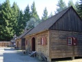 Granary, Storehouse and Clerks' House at Fort Nisqually reconstructed as they appeared in 1855.
