Davis Blockhouse: Difference between revisions
John Stanton (talk | contribs) No edit summary |
John Stanton (talk | contribs) No edit summary |
||
| Line 34: | Line 34: | ||
* [http://www.sunnysidecemetery.org/history/blockhouse.html Sunnyside Cemetery - Davis Blockhouse History] | * [http://www.sunnysidecemetery.org/history/blockhouse.html Sunnyside Cemetery - Davis Blockhouse History] | ||
{{Visited|14 Apr 2010, 21 Jun 2009}} | {{Visited|11 May 2014, 14 Apr 2010, 21 Jun 2009}} | ||
=={{PAGENAME}} Picture Gallery== | =={{PAGENAME}} Picture Gallery== | ||
Revision as of 07:18, 13 May 2014
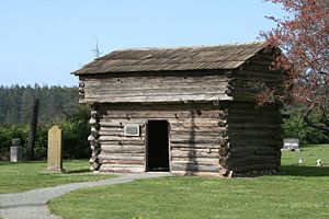
Davis Blockhouse (1857-1858) - A civilian blockhouse first established in 1857 during the Yakima Indian War (1855-1858) by settlers on Whidbey Island, Island County, Washington. Presumably named afterJames Davis, the owner of the donation claim where it was built. Abandoned as a fortification at the end of the war in 1858. Also known as Cook Blockhouse after later owners.
 |
 |
 | |
Davis Blockhouse History
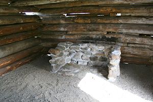
A two story blockhouse built on the southern border of the James Davis donation claim by the three Davis brothers (James Davis, John Davis and Thomas Davis). The blockhouse was built in November-December 1857 during the Yakima Indian War (1855-1858) in response to the August 1857 murder of Isaac Ebey by hostile Indians. The land claim and blockhouse were purchased by Cyrus and Sarah Cook at auction in 1868. The blockhouse sometimes took the name Cook Blockhouse from these owners. Later members of the Cook family donated the blockhouse and the local Ladies of the Roundtable organization took up a project to restore it in 1922. The restoration was completed in 1930-31 and Island County took ownership of the property as a part of the adjacent Sunneyside Cemetery.
Current Status
Now a part of the Island County Sunnyside Cemetery Blockhouse Addition. Restored and open to the public (the date on the plaque is incorrect).
|
{"selectable":false,"width":"500"} |
Location: Sunnyside Cemetery, Whidbey Island, Island County, Washington. Maps & Images Lat: 48.206098 Long: -122.706666 |
Sources:
- Roberts, Robert B., Encyclopedia of Historic Forts: The Military, Pioneer, and Trading Posts of the United States, Macmillan, New York, 1988, 10th printing, ISBN 0-02-926880-X, page 831.
- Hart, Herbert M., Tour Guide to Old Western Forts, Pruett Publishing Co., Boulder CO, 1980, ISBN 0-87108-568-2, page 183
Links:
Visited: 11 May 2014, 14 Apr 2010, 21 Jun 2009
Davis Blockhouse Picture Gallery
|
Click on the picture to see a larger version. Contribute additional pictures - the more the better! |