File list
Jump to navigation
Jump to search
This special page shows all uploaded files.
| Date | Name | Thumbnail | Size | User | Description | Versions |
|---|---|---|---|---|---|---|
| 12:16, 9 September 2018 | Tillamook Head RS Right Door.jpg (file) |  |
304 KB | John Stanton (talk | contribs) | Tillamook Head WWII RS Right Entrance, photo by John Stanton 8 Sep 2018 | 1 |
| 08:54, 9 September 2018 | Tillamook Head WWII RS Site.jpg (file) |  |
1.22 MB | John Stanton (talk | contribs) | Tillamook Head WWII Radar Site Ground Level Showing Air Intakes, photo by John Stanton 8 Sep 2018 | 1 |
| 07:17, 9 September 2018 | Cape Meares WWII Radar Site Overview.jpg (file) |  |
912 KB | John Stanton (talk | contribs) | Cape Meares WWII Radar Site Overview of Remains 2018, photo by John Stanton 8 Sep 2018 | 1 |
| 16:54, 7 September 2018 | CVAFS Sector 4 Comm Terminal.jpg (file) |  |
225 KB | John Stanton (talk | contribs) | Christmas Valley AFS Communications Terminal, public domain {{LOC|DigitalID=http://www.loc.gov/pictures/item/or0558.photos.366306p/}} | 1 |
| 15:45, 7 September 2018 | Christmas Valley AFS-S4-Garage-3 (1).jpg (file) | .jpg) |
298 KB | John Stanton (talk | contribs) | Christmas Valley AFS Sector 4-Garage, photo by John Stanton 4 Sep 2018 | 1 |
| 20:26, 6 September 2018 | Christmas Valley AFS-S5 Pwr.jpg (file) |  |
218 KB | John Stanton (talk | contribs) | Christmas Valley AFS Sector 5 Power Substation, photo by John Stanton 4 Sep 2018 | 1 |
| 20:14, 6 September 2018 | Christmas Valley AFS-S5 Water Tank.jpg (file) |  |
163 KB | John Stanton (talk | contribs) | Christmas Valley AFS Sector 5 Water Tank, photo by John Stanton 4 Sep 2018 | 1 |
| 20:05, 6 September 2018 | Christmas Valley AFS-S5-4.jpg (file) |  |
202 KB | John Stanton (talk | contribs) | Christmas Valley AFS Sector 5, photo by John Stanton 4 Sep 2018 | 1 |
| 19:59, 6 September 2018 | Christmas Valley AFS-S6-North-Ent.jpg (file) |  |
290 KB | John Stanton (talk | contribs) | Christmas Valley AFS Sector 4 "Cattle Chute Entrance", photo by John Stanton 4 Sep 2018 | 1 |
| 19:32, 6 September 2018 | CVAFS FPS-118 Antenna Detail.jpg (file) |  |
393 KB | John Stanton (talk | contribs) | Christmas Valley AFS FPS-118 Antenna Detail, public domain {{LOC|DigitalID=https://www.loc.gov/pictures/item/or0565.photos.366321p}} | 1 |
| 15:38, 6 September 2018 | OHT-B Antennas.jpg (file) |  |
104 KB | John Stanton (talk | contribs) | OTH-B Antenna Configurations, public domain {{OTH-BEnvAssUSAF}} | 1 |
| 15:29, 6 September 2018 | CVAFS Sector Layout.jpg (file) |  |
79 KB | John Stanton (talk | contribs) | Christmas Valley AFS Sector Layout, public domain {{OTH-BEnvAssUSAF}} | 1 |
| 16:28, 5 September 2018 | CVAFS FPS-118 Comp Room.jpg (file) |  |
188 KB | John Stanton (talk | contribs) | Christmas Valley AFS Sector 6, FPS-118, Empty Computer Room circa 2005, public domain {{LOC|DigitalID=https://www.loc.gov/pictures/item/or0564.photos.366319p photo by Robert Hicks, Historic American Buildings Survey (HABS).}} | 1 |
| 16:20, 5 September 2018 | CVAFS FPS-118 Transmitters.jpg (file) | 232 KB | John Stanton (talk | contribs) | Christmas Valley AFS FPS-118 Transmitters in Transmitter Building, {{LOC|DigitalID=https://www.loc.gov/pictures/item/or0564.photos.366318p}} | 1 | |
| 16:08, 5 September 2018 | CVAFS FPS-118 Sec 4 Tx Site.jpg (file) |  |
320 KB | John Stanton (talk | contribs) | Christmas Valley AFS Sector 4 Operations, {{LOC|DigitalID=http://www.loc.gov/rr/print/res/114_habs.html}} | 1 |
| 18:11, 29 August 2018 | Lyon Abbot 2.jpg (file) |  |
3.59 MB | Evan Coffey (talk | contribs) | 1 | |
| 18:09, 29 August 2018 | IMG 6161.jpg (file) |  |
3.4 MB | Evan Coffey (talk | contribs) | 1 | |
| 18:04, 29 August 2018 | Lyon Bayard 2.jpg (file) |  |
3.53 MB | Evan Coffey (talk | contribs) | 1 | |
| 18:02, 29 August 2018 | Lyon Bayard 1.jpg (file) |  |
4.28 MB | Evan Coffey (talk | contribs) | 1 | |
| 15:21, 27 August 2018 | Point Montara RS Power Bunker.jpg (file) |  |
211 KB | John Stanton (talk | contribs) | Point Montara RS Power Bunker, public domain from Photo from FUDS Report for Site No. J09CA077100 Camp Montara, San Mateo County, California. | 1 |
| 15:18, 27 August 2018 | Point Montara RS Operations Bunker.jpg (file) |  |
209 KB | John Stanton (talk | contribs) | Point Montara WWII Radar Site - Operations Bunker | 1 |
| 14:20, 27 August 2018 | Point Montara RS Antenna Mounts.jpg (file) |  |
162 KB | John Stanton (talk | contribs) | Point Montara WWII Radar Site Antenna Mounts, public domain from FUDS Report for Site No. J09CA077100 Camp Montara, San Mateo County, California. | 1 |
| 17:09, 26 August 2018 | M-7 Generator Doors Open.jpg (file) |  |
154 KB | John Stanton (talk | contribs) | M-7 Generator Set, Doors Open, public domain [https://usacac.army.mil/cac2/cgsc/carl/wwIItms/TM9_618_1943.pdf TM-9-618] | 1 |
| 15:24, 26 August 2018 | SCR-584 Console.jpg (file) |  |
227 KB | John Stanton (talk | contribs) | SCR-584 Operators Console, public domain [https://en.wikipedia.org/wiki/SCR-584_radar#/media/ WikiMedia] | 1 |
| 15:16, 26 August 2018 | SCR-584 at Peleliu.jpg (file) |  |
77 KB | John Stanton (talk | contribs) | SCR-584 at Peleliu, Antenna on Left is for the RC-184 IFF Set, public domain [https://commons.wikimedia.org/wiki/File:SCR548-radar-peleliu.jpg WikiMedia] | 1 |
| 15:11, 26 August 2018 | SCR-584 Exterior.jpg (file) |  |
211 KB | John Stanton (talk | contribs) | SCR-584 Exterior, public domain [https://commons.wikimedia.org/wiki/File:Exterior_view_of_SCR-584.jpg WikiMedia] | 1 |
| 15:02, 26 August 2018 | SCR-584 Installation.jpg (file) |  |
119 KB | John Stanton (talk | contribs) | Sketch of SCR-584 Installation, public domain [https://www.history.navy.mil/research/library/online-reading-room/title-list-alphabetically/u/operational-characteristics-of-radar-classified-by-tactical-application.html#anti U.S. Navy - U.S. Radar Operat... | 1 |
| 08:49, 22 August 2018 | SCR-588 Op Positions.jpg (file) |  |
109 KB | John Stanton (talk | contribs) | SCR-588 Operator Positions, public domain photo from unidentified Army Tech Manual | 1 |
| 08:45, 22 August 2018 | SCR-588 Transmitter.jpg (file) | 107 KB | John Stanton (talk | contribs) | SCR-588 Transmitter, public domain photo from unidentified Army Tech Manual | 1 | |
| 19:35, 21 August 2018 | SCR-588 Antenna Installed.jpg (file) |  |
389 KB | John Stanton (talk | contribs) | SCR-588 Antenna Installed, public domain from tech manual | 1 |
| 19:04, 21 August 2018 | SCR-588 Site Drawing.png (file) |  |
261 KB | John Stanton (talk | contribs) | SCR-588 Site Drawing, * [https://www.history.navy.mil/research/library/online-reading-room/title-list-alphabetically/u/operational-characteristics-of-radar-classified-by-tactical-application.html#gci A Site Layout Drawing, public domain, US Radar/ Oper... | 1 |
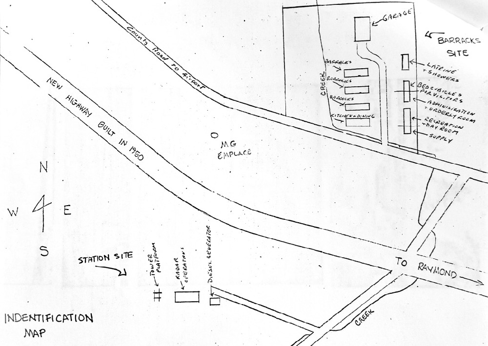
| 18:59, 18 August 2018 | Baleville RS Plan.jpg (file) |  |
159 KB | John Stanton (talk | contribs) | Baleville WWII Radar Site Plan, unattributed sketch at Pacific County Historical Society and Museum, photo by John Stanton 16 Aug 2018 | 1 |
| 18:20, 18 August 2018 | Baleville WWII RS-Cant Site.jpg (file) |  |
241 KB | John Stanton (talk | contribs) | Empty Baleville WWII Radar Site Cantonment Area, photo by John Stanton 14 Aug 2018 | 1 |
| 17:47, 18 August 2018 | Baleville WWII RS-Ant Supports.jpg (file) |  |
232 KB | John Stanton (talk | contribs) | Baleville WWII Radar Site - Antenna Concrete Supports in 2018, photo by John Stanton 16 Aug 2018 | 1 |
| 17:32, 18 August 2018 | Baleville WWII RS-Power Bldg.jpg (file) |  |
171 KB | John Stanton (talk | contribs) | Baleville WWII Radar Site - Repurposed Power Building in 2018, photo by John Stanton 16 Aug 2018 | 1 |
| 16:33, 18 August 2018 | Baleville WWII RS-Ops Bldg.jpg (file) |  |
647 KB | John Stanton (talk | contribs) | Baleville WWII Radar Site - Ops Bldg, photo by John Stanton 17 Aug 2018 | 1 |
| 10:32, 5 August 2018 | Dow BOMARC Entrance.jpg (file) |  |
159 KB | John Stanton (talk | contribs) | Dow AFB BOMARC Missile Site Entrance. photo by John Stanton 26 May 2018 | 1 |
| 10:16, 5 August 2018 | Dow BOMARC Heat-Power Bldg.jpg (file) |  |
130 KB | John Stanton (talk | contribs) | Dow AFB BOMARC Heating and Power Bldg. photo by John Stanton 26 May 2018 | 1 |
| 10:12, 5 August 2018 | Dow BOMARC Assembly Bldg.jpg (file) |  |
171 KB | John Stanton (talk | contribs) | Dow AFB BOMARC Missile Assembly Bldg. photo by John Stanton 26 May 2018 | 1 |
| 10:03, 5 August 2018 | Dow BOMARC Launch Shelters.jpg (file) |  |
413 KB | John Stanton (talk | contribs) | Repurposed Dow AFB BOMARC Missile Launch Shelters. Originally these buildings had flat retractable roofs that exposed the missile and launcher when opened. photo by John Stanton 26 May 2018 | 1 |
| 06:37, 5 August 2018 | Dow Bomarc Site Plan.png (file) |  |
640 KB | John Stanton (talk | contribs) | Dow Bomarc Site Plan, drawing by John Stanton 5 Aug 2018 | 1 |
| 08:04, 3 August 2018 | Kennebec County Courthouse.jpg (file) |  |
662 KB | John Stanton (talk | contribs) | Kennebec County Courthouse, photo by John Stanton 27 May 2018 | 1 |
| 16:53, 27 July 2018 | Boston Hill Radar Site.jpg (file) |  |
116 KB | John Stanton (talk | contribs) | Boston Hill MITRE Rada Test Site, unattributed photo from http://www.newenglandskihistory.com/Massachusetts/bostonhills.php | 1 |
| 06:39, 23 July 2018 | West Bath LRR Test Site.jpg (file) |  |
609 KB | John Stanton (talk | contribs) | West Bath Long Range Radar Test Site, photo by John Stanton 27 May 2018 | 1 |
| 18:16, 20 July 2018 | Topsham Air Force Station.jpg (file) |  |
400 KB | John Stanton (talk | contribs) | Topsham Air Force Station, photo of a museum display at the Brunswick Naval Museum and Memorial Garden by John Stanton | 1 |
| 15:32, 20 July 2018 | Brunswick FirstLight Data Center.jpg (file) |  |
187 KB | John Stanton (talk | contribs) | FirstLight Data Center on Former Brunswick AFS, photo by John Stanton 27 May 2018. | 1 |
| 15:24, 20 July 2018 | Brunswick AFS Height Finder Twr.jpg (file) |  |
180 KB | John Stanton (talk | contribs) | Remaining Height Finder Tower on the former Brunswick AFS, photo by John Stanton 27 May 2018 | 1 |
| 07:34, 19 July 2018 | Brunswick AFS c1966.jpg (file) |  |
542 KB | John Stanton (talk | contribs) | Brunswick Air Force Station circa 1966, photo of an unattributed photo at Brunswick Naval Museum by John Stanton 27 May 2018 | 1 |
| 17:43, 18 July 2018 | Marker Ft Andros Ft George (1).jpg (file) | .jpg) |
268 KB | John Stanton (talk | contribs) | Fort Andros/Fort George Marker, photo by John Stanton 27 May 2018 | 1 |
| 07:23, 18 July 2018 | Marker Ft Andros Ft George Location.jpg (file) |  |
507 KB | John Stanton (talk | contribs) | 1834 Cabot Mill Building on the Site of Fort George and Fort Andros, photo by John Stanton 27 May 2018 | 1 |