Fort Rosalie
|
Fort Rosalie (1716-1799) - A French post established in 1716 by the governor of Louisiana, Jean-Baptiste Le Moyne de Bienville, in present-day Natchez, Adams County, Mississippi. Named for the duchess of Pontchartrain who was the wife of the French minister of marine. Burned by Indians in 1729. Taken over and rebuilt by the British after the French & Indian War and renamed Fort Panmure. The post was occupied by American forces during the Revolutionary War but retaken by the British in 1782 and then surrendered to the Spanish on 22 Sep 1783, and occupied by them until 1798. Occupied by Americans in 1798 but abandoned when Fort Adams (3) was completed in 1799. Also known as Fort les Natchez, Post at Natchez, Natchez Post, Fort Sargent and Fort Panmure.
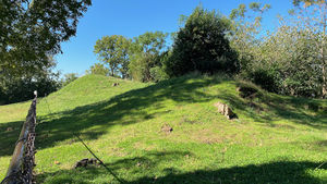
HistoryCurrent StatusFort Rosalie is now a part of the Natchez National Historical Park. The site of the Fort is located just south of the Rosalie House in Natchez, Adams County, Mississippi. The site is located within a large grassy block along Canal Street that has a number of readerboards along the perimeter. The remains of the fort's main redoubt are located at a central high point at the crest of a tall bluff overlooking the Mississippi River. The site of a landside gun battery is located on an elevation below the main bastion. Neither of these defenses is well defined now and it takes a lot of imagination to know what they must have looked like. The remains of the redoubt are fenced off to limit public access. To get a full picture of the reason the fort existed one should visit the Grand Village of the Natchez Indians nearby and understand that there were also two Indian forts built between the Indian village and the French fort. A third fort was built in Louisiana by Indians fleeing the retaliating French forces.
See Also: Sources:
Links: Visited: 31 Oct 2020
| |||||||

