Category:Fort Stevens


Fort Stevens (1865-1947) - Named for General Isaac Stevens a Governor of the Washington Territory. The fort was built under supervision of the United States Engineers starting in July 1863. It was completed 8 Apr 1865 and was first occupied by a company of the Eighth California Volunteers, 25 April 1865. The garrison was withdrawn in 1882 and the post placed in the charge of an ordinance sergeant.
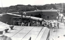
In 1897 Fort Stevens underwent a massive re-fortification program to improve coastal defense that resulted in the construction of 8 concrete batteries around the original site.
Fort Stevens was further modified during World War II and had the distinction of being the only stateside installation attacked by enemy forces since the war of 1812 when a Japanese submarine I25 fired 17 shells close to the fort. After the war Fort Stevens was deactivated and by 1947 all the armament had been removed. Oregon State Parks leased the old fort area in 1975 and is restoring and interpreting the fort.
|
Forts and Batteries on Fort Stevens | |
|
|
|
{"selectable":false,"width":"500"} |
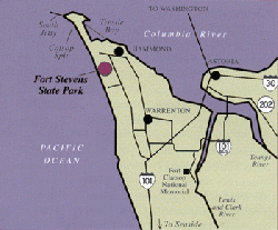
Location: Situated at the mouth of the Columbia River and located nine miles from Astoria in Clatsop County, Oregon. Maps & Images Lat: 46.206953 Long: -123.962688 |
Sources:
Links:
Picture Gallery
|
Click on the pictures to see a larger version. |
-
Map of Fort Steven Facilities, photo by J Stanton, Feb 2006
-
Barracks at Fort Stevens, 1954
-
Guardhouse at Fort Stevens, 1954
-
Officer Quarters at Fort Stevens, 1962
-
Batteries Pratt, Lewis and Walker at Fort Stevens, JStanton, Feb 2006
-
Battery Lewis at Fort Stevens, JStanton, Feb 2006
-
Battery Walker at Fort Stevens, JStanton, Feb 2006
-
Battery Pratt at Fort Stevens, JStanton, Feb 2006
-
Replica of 6-inch Rifle at Battery Pratt, JStanton, Feb 2006
-
Sallyport and Gun for the Earthworks Fort at Fort Stevens, JStanton, Feb 2006
-
Moat Surrounding the Earthworks Fort at Fort Stevens, JStanton, Feb 2006
-
Inside the Earthworks Fort at Fort Stevens, JStanton, Feb 2006
-
Battery 245 at Fort Stevens, JStanton, Feb 2006
-
South Jetty at Fort Stevens, JStanton, Feb 2006
Pages in category "Fort Stevens"
The following 11 pages are in this category, out of 11 total.


