Battery Strong: Difference between revisions
John Stanton (talk | contribs) |
John Stanton (talk | contribs) m Text replace - "width="500"" to "width="-500" height="-500"" |
||
| (23 intermediate revisions by 2 users not shown) | |||
| Line 1: | Line 1: | ||
{{PageHeader}} | |||
{{SocialNetworks}} | {{SocialNetworks}} | ||
{{ | '''{{PAGENAME}}''' (1937-1946) - A [[World War II]] era Battery built in 1937 as a reinforced concrete coastal artillery battery on [[Fort Rosecrans]], San Diego County, California. Named after Major General [[Frederick S. Strong]] {{Cullum|2837}}, who graduated from the [[United States Military Academy]] at West Point in the [[:Category:West Point 1880|Class of 1880]] and was appointed a lieutenant in the [[4th U.S. Artillery]]. General Strong served in World War I, died in 1935 and was buried in [[:Category:Arlington National Cemetery|Arlington National Cemetery]]. Construction began in February 1937 and was completed June 1937. The Battery was turned over for service 12 Oct 1942 at a cost of $100,725.59. Deactivated in 1946. | ||
{|{{FWpicframe}} | |||
Battery Strong was a battery of two, 8" rapid fire Barbette mounted guns on either side of an earth covered reinforced concrete support structure. Ammunition was served by hand trucks on narrow gage | |- valign="top" | ||
|width="50%"|[[File:Battery Strong - 3.jpg|350px|thumb|left|Battery Strong Gun Emplacement #2]] | |||
|width="50%"|[[File:Battery Strong - 4.jpg|350px|thumb|right|Battery Strong Emplacement #2 Magazine Entrance]] | |||
|- | |||
|colspan="2"|[[File:Battery Strong - 2.jpg|795px|thumb|center|Battery Strong Emplacement #1 Magazine Entrance]] | |||
|} | |||
== History == | |||
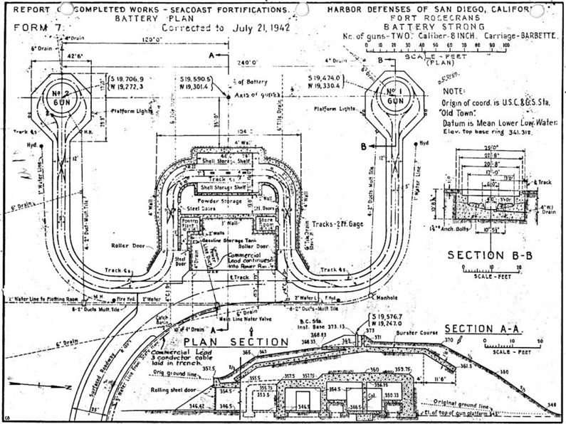
Battery Strong was a battery of two, 8" rapid fire Barbette mounted guns on either side of an earth covered reinforced concrete support structure. Ammunition was served by hand trucks on narrow gage tracks. The gun tubes were mounted in April 1941. | |||
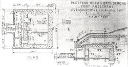
[[File:Battery Strong Plotting Room Plan.jpg|thumb|left|250px|Battery Strong Plotting Room Plan]] | |||
An underground reinforced concrete plotting room was located about 540' south and 24 degrees east of gun emplacement #2. The plotting room was accepted for service 12 Oct 1942 at a cost of $19,145.63. | |||
On 12 Jan 1945 an SCR-296A fire control radar was placed in service to support Battery Strong. This radar site was located right at the Mexican Border and connected to the command structure and the Battery Strong plotting room by telephone land lines. | |||
{{Clr}} | {{Clr}} | ||
{{FtRosecransBatteryStrong}} | {{FtRosecransBatteryStrong}} | ||
[[Image:BatteryStrong Plan.jpg|thumb|795px|left|Battery Strong Plan]] | [[Image:BatteryStrong Plan.jpg|thumb|795px|left|Battery Strong Plan]] | ||
{{Clr}} | {{Clr}} | ||
== Deactivation == | |||
The battery was deactivated in 1946 but the battery structure has been repurposed and is currently in use. | |||
== Current Status == | == Current Status == | ||
Part of | Part of NSC San Diego Point Loma Annex. No period guns or carriages in place. No public access. | ||
---- | ---- | ||
{| | {| | ||
| | | | ||
<googlemap lat="32. | <googlemap version="0.9" lat="32.696482" lon="-117.24825" zoom="17" width="-500" height="-500" scale="yes" overview="yes" controls="large" icons="http://www.fortwiki.com/mapicons/icon{label}.png"> | ||
(B) 32.697067, -117.248666, | (B) 32.697067, -117.248666, Battery Strong | ||
(1) 32.697304, -117.249039, | (1937-1946) | ||
(2) 32.696665, -117.248851, | (1) 32.697304, -117.249039, Gun Emplacement #1 | ||
(2) 32.696665, -117.248851, Gun Emplacement #2 | |||
(P) 32.695312, -117.2480196, Battery Strong Plotting Room | |||
</googlemap> | </googlemap> | ||
|valign="top"| | |valign="top"| | ||
'''Location:''' | '''Location:''' NSC San Diego Point Loma Annex, San Diego County, California. | ||
{{Mapit-US-cityscale|32.697067|-117.248666}} | {{Mapit-US-cityscale|32.697067|-117.248666}} | ||
* Elevation: | * Elevation: 347' | ||
|} | |} | ||
'''Sources:''' | '''Sources:''' | ||
* {{ | {{HBSuppSanDiegoWWII}} | ||
* RCW Form 1, Form 7 - Battery Strong, Corrected to 28 Oct 1942, NARA, CDSG. | |||
* {{Berhow}}, pages 114-115 | |||
* {{GunCards}} | |||
'''Links: ''' | '''Links: ''' | ||
* {{ | * [http://www.nps.gov/history/history/online_books/cabr/hrs6.htm National Park Service - Fort Rosecrans] | ||
{{Visited|}} | * {{CDSGBatteryLink}} | ||
{{Visited|2 Oct 2014}} | |||
{{PageFooter}} | |||
__NOTOC__ | __NOTOC__ | ||
| Line 49: | Line 62: | ||
[[Category:World War II Battery]] | [[Category:World War II Battery]] | ||
[[Category:Coastal Battery]] | [[Category:Coastal Battery]] | ||
[[Category:California San Diego County]] | |||
[[Category:Harbor Defense of San Diego]] | |||
[[Category:{{PAGENAME}}]] | [[Category:{{PAGENAME}}]] | ||
[[Category:Fort Rosecrans]] | [[Category:Fort Rosecrans]] | ||
[[Category: | [[Category:2015 Research Trip]] | ||
[[Category: | [[Category:CDSG Conference 2014]] | ||
Latest revision as of 18:12, 7 January 2019
|
HistoryBattery Strong was a battery of two, 8" rapid fire Barbette mounted guns on either side of an earth covered reinforced concrete support structure. Ammunition was served by hand trucks on narrow gage tracks. The gun tubes were mounted in April 1941.  An underground reinforced concrete plotting room was located about 540' south and 24 degrees east of gun emplacement #2. The plotting room was accepted for service 12 Oct 1942 at a cost of $19,145.63. On 12 Jan 1945 an SCR-296A fire control radar was placed in service to support Battery Strong. This radar site was located right at the Mexican Border and connected to the command structure and the Battery Strong plotting room by telephone land lines.

DeactivationThe battery was deactivated in 1946 but the battery structure has been repurposed and is currently in use. Current StatusPart of NSC San Diego Point Loma Annex. No period guns or carriages in place. No public access.
Sources:
Links: Visited: 2 Oct 2014 | ||||||||||||||||||||||||||||||||||||||||||||||


