Long Point Military Reservation: Difference between revisions
John Stanton (talk | contribs) No edit summary |
John Stanton (talk | contribs) m Text replace - "width="500"" to "width="-500" height="-500"" |
||
| (23 intermediate revisions by the same user not shown) | |||
| Line 1: | Line 1: | ||
{{SocialNetworks}} | {{SocialNetworks}} | ||
'''{{PAGENAME}}''' (1930- | {{PageHeader}} | ||
'''{{PAGENAME}}''' (1930-1944) - An Coastal Military Reservation first established in 1930 above Long Point and Point Vincente in the present day city of Rancho Palos Verdes, Los Angeles County, California. A sub-post of [[Fort MacArthur]]. Abandoned in 1944. | |||
{|{{FWpicframe}} | {|{{FWpicframe}} | ||
|- valign="top" | |- valign="top" | ||
|width="50%"|[[File: | |width="50%"|[[File:Long Point MR - FC - 06.jpg|300px|thumb|left|Long Point from Fire Control Station]] | ||
|width="50%"|[[File: | |width="50%"|[[File:Long Point MR - FC - 08.jpg|300px|thumb|right|Long Point MR 1930 Fire Control Station]] | ||
|- | |- | ||
|colspan="2"|[[File:Long Point MR - FC - 15.jpg|795px|thumb|center|Long Point MR 1930 Fire Control Station]] | |colspan="2"|[[File:Long Point MR - FC - 15.jpg|795px|thumb|center|Long Point MR 1930 Fire Control Station]] | ||
| Line 11: | Line 12: | ||
{{HDLosAngeles}} | {{HDLosAngeles}} | ||
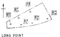
[[File:Long Point MR 1930s Plan.jpg|thumb|left|200px|Long Point MR 1930s Plan]] | [[File:Long Point MR 1930s Plan.jpg|thumb|left|200px|Long Point MR 1930s Plan]] | ||
The Long Point Military Reservation was initially acquired in 1930 to house six fire control stations for the large caliber guns at [[Fort MacArthur]]. The initial site was a small hillside reservation overlooking the Pacific Ocean at Long Point. The fire control stations were rectangular reinforced concrete structures built into a steep hillside. These fire control stations still remain in place. | |||
The Long Point Military Reservation was initially acquired in 1930 to house six fire control stations for the large caliber guns at [[Fort MacArthur]]. The initial site was a small hillside reservation overlooking the Pacific Ocean at Long Point. The fire control stations were rectangular reinforced concrete structures built into a steep hillside. | |||
{{Clr}} | {{Clr}} | ||
== [[World War II]] (1941-1945) == | == [[World War II]] (1941-1945) == | ||
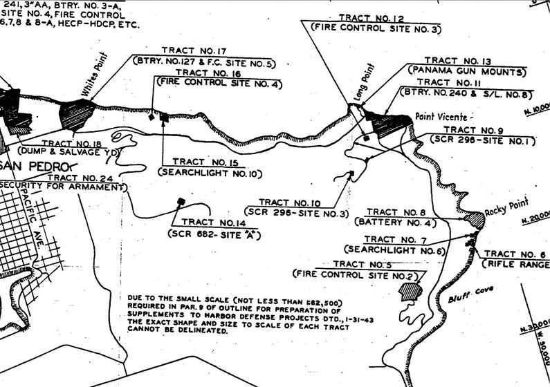
In the opening days of [[World War II]], Battery B of the [[3rd U.S. Coast Artillery]] moved two 155mm GPF guns from the upper reservation gun park at [[Fort MacArthur]] to emplacements at [[Long Point Military Reservation]]. These were temporary field emplacements that were later replaced by two Panama mounts. The Panama mounts were completed by the end of March 1942 and the guns were emplaced there until [[Battery 240]] was completed and proof fired in 1943. The emplacements were located on the north side of Long Point below the 1930s fire control stations. | In the opening days of [[World War II]], Battery B of the [[3rd U.S. Coast Artillery]] moved two 155mm GPF guns from the upper reservation gun park at [[Fort MacArthur]] to emplacements at [[Long Point Military Reservation]]. These were temporary field emplacements that were later replaced by two Panama mounts. The Panama mounts were completed by the end of March 1942 and the guns were emplaced there until [[Battery 240]] was completed and proof fired in 1943. The emplacements were located on the north side of Long Point below the 1930s fire control stations. | ||
The lease on the reservation was terminated on 6 Oct 1944. | |||
{{Clr}} | {{Clr}} | ||
{{MrLongPointWWII}} | {{MrLongPointWWII}} | ||
[[File:Long Point | [[File:Long Point Army Tracts 1944.jpg|thumb|left|795px|Army Controlled Land Tracts near Long Point, 1944. Tract #13 is the Long Point MR]] | ||
{{Clr}} | {{Clr}} | ||
== Current Status == | == Current Status == | ||
No remains of the 155mm gun emplacements. | |||
---- | |||
{| | {| | ||
| | | | ||
<googlemap version="0.9" lat="33.753603" lon="-118.38747" zoom="13" width="500" scale="yes" overview="yes" controls="large" icons="http://www.fortwiki.com/mapicons/icon{label}.png"> | <googlemap version="0.9" lat="33.753603" lon="-118.38747" zoom="13" width="-500" height="-500" scale="yes" overview="yes" controls="large" icons="http://www.fortwiki.com/mapicons/icon{label}.png"> | ||
(M) 33.7447911, -118.4045523, Long Point Military Reservation | (M) 33.7447911, -118.4045523, Long Point Military Reservation | ||
(1930-1974) | (1930-1974) | ||
(B) 33.739374, -118.401622, Battery 155 - Long Point | (B) 33.739374, -118.401622, Battery 155 - Long Point | ||
(1941-1943) | (1941-1943) | ||
| Line 64: | Line 48: | ||
</googlemap> | </googlemap> | ||
|valign="top"| | |valign="top"| | ||
'''Location:''' | '''Location:'''Rancho Palos Verdes, Los Angeles County, California. | ||
{{Mapit-US-cityscale|33.7447911|-118.4045523}} | {{Mapit-US-cityscale|33.7447911|-118.4045523}} | ||
* Elevation: ' | * Elevation: ' | ||
|} | |} | ||
'''Recent Blog Posts:''' | |||
* [http://www.usforts.com/2013/01/long-point-military-reservation.html U.S. Forts - Long Point Military Reservation, California] | |||
'''Sources:''' | '''Sources:''' | ||
* Berhow, Mark A. and Gustafson, David, '''''The Guardian at Angels Gate Fort MacArthur Defender of Los Angeles''''', CDSG ePress electronic edition, 2011, 99 pages, [http://www.cdsg.org/HDpac/FtMacBook11.pdf Large pdf] | |||
* USACE, '''''FUDS - Archives Search Report Findings - Point Vicente Seacoast Defense Sites''''', USACE Project Number J09CA055802, April 1996, USACE St. Louis District, 301 Pages, [ftp://swrcb2a.swrcb.ca.gov/pub/swrcb/dwq/dodscp/CA%20INPRS%20and%20ASRs%20LA%20District/ASRs/J09CA055802.pdf Large pdf] | |||
{{HBSuppLosAngelesWWII}} | {{HBSuppLosAngelesWWII}} | ||
| Line 80: | Line 69: | ||
{{Visited|4 Jan 2013}} | {{Visited|4 Jan 2013}} | ||
{{PageFooter}} | |||
__NOTOC__ | __NOTOC__ | ||
| Line 97: | Line 82: | ||
[[Category:{{PAGENAME}}]] | [[Category:{{PAGENAME}}]] | ||
[[Category:Preserved]] | [[Category:Preserved]] | ||
[[Category:World War II Forts]] | [[Category:World War II Forts]] | ||
[[Category:Military Reservations]] | [[Category:Military Reservations]] | ||
[[Category:Starter Page]] | [[Category:Starter Page]] | ||
[[Category:2013 Research Trip]] | [[Category:2013 Research Trip]] | ||
Latest revision as of 18:16, 7 January 2019
|
Long Point Military Reservation (1930-1944) - An Coastal Military Reservation first established in 1930 above Long Point and Point Vincente in the present day city of Rancho Palos Verdes, Los Angeles County, California. A sub-post of Fort MacArthur. Abandoned in 1944.
Part of the Harbor Defense of Los Angeles.  The Long Point Military Reservation was initially acquired in 1930 to house six fire control stations for the large caliber guns at Fort MacArthur. The initial site was a small hillside reservation overlooking the Pacific Ocean at Long Point. The fire control stations were rectangular reinforced concrete structures built into a steep hillside. These fire control stations still remain in place.
World War II (1941-1945)In the opening days of World War II, Battery B of the 3rd U.S. Coast Artillery moved two 155mm GPF guns from the upper reservation gun park at Fort MacArthur to emplacements at Long Point Military Reservation. These were temporary field emplacements that were later replaced by two Panama mounts. The Panama mounts were completed by the end of March 1942 and the guns were emplaced there until Battery 240 was completed and proof fired in 1943. The emplacements were located on the north side of Long Point below the 1930s fire control stations. The lease on the reservation was terminated on 6 Oct 1944.

Current StatusNo remains of the 155mm gun emplacements.
Recent Blog Posts: Sources:
Links:
Visited: 4 Jan 2013 | |||||||||||||||||||||||||||


