Fort Simcoe: Difference between revisions
John Stanton (talk | contribs) No edit summary |
John Stanton (talk | contribs) No edit summary |
||
| Line 34: | Line 34: | ||
'''See Also:''' | '''See Also:''' | ||
* [[Yakima War]]] | |||
* [[Fort Dalles]] | * [[Fort Dalles]] | ||
Revision as of 11:25, 24 August 2016
|
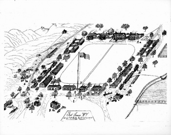
Fort Simcoe (1856-1859) - Established on 8 Aug 1856 by Major Robert Seldon Garnett and Companies G and F of the 9th U.S. Infantry Regiment. The fort was located at the "bubbling spring" on Toppenish Creek near the site of Haller's defeat, Yakima County, Washington. Major Garnett was the first commander at Fort Simcoe. Abandoned in 1859 and became Yakima Indian Agency.
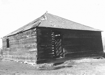
Fort Simcoe HistoryFort Simcoe was designed by architect Louis Scholl who also designed Fort Dalles. It had a blockhouses at each corner of the post but no stockade, each blockhouse was a standalone fortification. A 420' square parade ground was surrounded by log and frame barracks and service buildings within the boundaries defined by the blockhouses. The fort was used as the Yakima Indian Agency beginning in 1859 after the garrison transferred to Fort Colville. It was abandoned in 1923. The state leased the state park property from the Yakima Nation in 1953. In 1956, Fort Simcoe became a state park, and in 1974 it was added to the National Register of Historic Places.
Current StatusMust See! The fort has been restored and contains three original officers quarters (1857-1858), one original blockhouses (1856), and the original Commandant's House (1857-1858). In addition to the five original buildings, four buildings have been replicated including a barracks, the guardhouse and two blockhouses. The four original officer's quarters have period furnishings. This is a fine example of the 1850s Washington Indian wars period forts and is probably the most complete. The park is located some 30 miles to the west of Toppenish in Yakima County on the Yakima Indian Reservation. Access from I-82 or US 97 at Toppenish. The grounds are open daily from April 1 to October 1 but the restored officers quarters with interior furnishing and the interpretive center are currently open to the public 9:30 a.m. to 4:30 p.m., Wednesday through Sunday. Tours the rest of the year may be made by appointment, call 509-874-2372. (as of 2016)
See Also: Sources:
Links: Visited: 22 Aug 2016 | ||||||||||||||||||||||||||||||||||||||||||


