Camp River Dubois: Difference between revisions
John Stanton (talk | contribs) No edit summary |
John Stanton (talk | contribs) No edit summary |
||
| Line 12: | Line 12: | ||
== {{PAGENAME}} History == | == {{PAGENAME}} History == | ||
== Current Status == | == Current Status == | ||
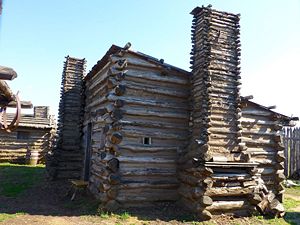
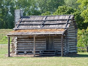
The camp is recreated in the Lewis & Clark State Historic Site, Madison County, Illinois. | The camp is recreated in the Lewis & Clark State Historic Site, Madison County, Illinois. The museum in the visitor's center has an exceptional cutaway keel boat display that illustrates the supplies and cargo that the expedition had to carry with them on the two year journey. | ||
<gallery> | <gallery> | ||
Image:Lewis & Clark State Historic Site - 11.jpg|Keel Boat Display | Image:Lewis & Clark State Historic Site - 11.jpg|Keel Boat Display | ||
Image:Lewis & Clark State Historic Site - 04.jpg|Keel Boat Display Cutaway Side | Image:Lewis & Clark State Historic Site - 04.jpg|Keel Boat Display Cutaway Side | ||
Image:Lewis & Clark State Historic Site - 05.jpg|Keel Boat Display Cabin | Image:Lewis & Clark State Historic Site - 05.jpg|Keel Boat Display Cabin | ||
Image:Lewis & Clark State Historic Site - 03.jpg|Keel Boat Display Full Cutaway Side | |||
</gallery> | </gallery> | ||
{{Clr}} | |||
---- | |||
{| | {| | ||
| | | | ||
Revision as of 17:00, 27 August 2012
Camp River Dubois (1803-1804) - Established in 1803 by the Lewis & Clark expedition on the east bank of the Mississippi River in present day Madison County, Illinois. Abandoned in 1804 when the expedition departed. Also known as Camp Dubois.
 |
 |
 | |
Camp River Dubois History
Current Status
The camp is recreated in the Lewis & Clark State Historic Site, Madison County, Illinois. The museum in the visitor's center has an exceptional cutaway keel boat display that illustrates the supplies and cargo that the expedition had to carry with them on the two year journey.
-
Keel Boat Display
-
Keel Boat Display Cutaway Side
-
Keel Boat Display Cabin
-
Keel Boat Display Full Cutaway Side
|
{"selectable":false,"width":"500"} |
Location: Lewis & Clark State Historic Site, Madison County, Illinois. Map point is the recreated camp. Maps & Images Lat: 38.801651 Long: -90.10298 |
Sources:
- Roberts, Robert B., Encyclopedia of Historic Forts: The Military, Pioneer, and Trading Posts of the United States, Macmillan, New York, 1988, 10th printing, ISBN 0-02-926880-X, page 262
Links:
- North American Forts - Camp River Dubois
- Wikipedia - Camp Dubois
- Wikipedia - Lewis & Clark State Historic Site
Visited: 27 Aug 2012
Camp River Dubois Picture Gallery
|
Click on the picture to see a larger version. Contribute additional pictures - the more the better! |


