Fort Furieuse: Difference between revisions
John Stanton (talk | contribs) m Text replace - "<seo metadescription="Historic US and Canadian fortifications" /> " to "<seo metadescription="Historic US and Canadian fortifications" /> {| style="margin: 1em auto 1em auto" width="800px" |- | " |
John Stanton (talk | contribs) m Text replace - "{{DEFAULTSORT:" to "|} {{DEFAULTSORT:" |
||
| Line 43: | Line 43: | ||
__NOTOC__ | __NOTOC__ | ||
{{PageFooter}} | |||
{{DEFAULTSORT:Furieuse}} | {{DEFAULTSORT:Furieuse}} | ||
[[Category:All]] | [[Category:All]] | ||
Revision as of 07:56, 24 February 2015
|
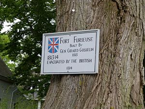
Fort Furieuse (1814-1815) - A British War of 1812 fort established in 1814 by British General Girard Gosselin in present day Castine, Hancock County, Maine. Abandoned in 1815.
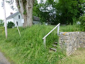
War of 1812 (1812-1814)Fort Furieuse was established after the British capture of Castine in September 1814. This fort was built as one of a series of smaller fortifications surrounding the main British fort on the peninsula, Fort George. The other British fortifications included Fort Griffith, Fort Sherbrooke (2), Fort Gosselin, the captured Fort Madison (1) (renamed Fort Castine) and a number of gun batteries. The fort was dismantled when the British left in April 1815. Current StatusMarker only on private property, Castine, Hancock County, Maine
Sources:
Links: Visited: 28 Jun 2012 Fort Furieuse Picture Gallery
| |||||||

