Long Point Military Reservation
Long Point Military Reservation (1930-1974) - An Coastal Military Reservation first established in 1930 above Long Point and Point Vincente in the present day city of Rancho Palos Verdes, Los Angeles County, California. A sub-post of Fort MacArthur. Abandoned in 1974.
 |
 |
 | |
Part of the Harbor Defense of Los Angeles.


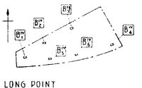
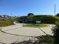
The Long Point Military Reservation was initially acquired in 1930 to house six fire control stations for the large caliber guns at Fort MacArthur. The initial site was a small hillside reservation overlooking the Pacific Ocean at Long Point. The fire control stations were rectangular reinforced concrete structures built into a steep hillside.
World War II (1941-1945)

| Battery Click on Battery links below |
No. | Caliber | Type Mount | Service Years | Battery Cost | Notes |
|---|---|---|---|---|---|---|
| Battery 155 - Long Point | 2 | 155mm | Mobile, Panama Mounts | 1941-1942-1943-1944 | $ 8,208 | |
| Source: CDSG | ||||||

Cold War (1947–1991)
| Battery | Type | Location | Operational | Deactivated | GPS | Notes |
|---|---|---|---|---|---|---|
| LA-45H | Headquarters | Fort MacArthur | 33.72225, -118.28657 |
|||
| LA-41H | Headquarters | Long Beach | 33.796621, -118.151005 |
|||
| LA-45DC | Command Post | San Pedro Hill AFS, CA | 1960 | 1974-09-01 | 33.71378, -118.28706 |
|
| RP-39 | Radar | San Pedro Hill | 33.7466931, -118.3366179 |
Radar Only | ||
| LA-04C | Control | Mt Gleason | 1956 | 1974 | 34.375556, -118.175833 |
|
| LA-04L | Launch | Mt Gleason | 1956 | 1974 | 34.378056, -118.150833 |
|
| LA-09C | Control | Mt Disappointment | 1956 | 1961 | 34.246667, -118.104722 |
|
| LA-09L | Launch | Barley Flats | 1956 | 1961 | 34.278333, -118.075556 |
|
| LA-14C | Control | El Monte | 1956 | 1961 | 34.018056, -118.038056 |
|
| LA-14L | Launch | El Monte | 1956 | 1961 | 34.043611, -118.058889 |
|
| LA-29C | Control | Puente Hills | 1958 | 1971 | 33.955278, -117.895556 |
|
| LA-29L | Launch | Puente Hills | 1958 | 1971 | 33.959444, -117.886111 |
|
| LA-32C | Control | Stanton | 1956 | 1974 | 33.790833, -118.011944 |
|
| LA-32L | Launch | Stanton | 1956 | 1974 | 33.792222, -118.002778 |
|
| LA-40C | Control | Long Beach Airport | 1956 | 1963 | 33.808889, -118.135556 |
|
| LA-40L | Launch | Long Beach Airport | 1956 | 1963 | 33.808889, -118.140556 |
|
| LA-43C | Control | Fort MacArthur | 1955 | 1974 | 33.712359, -118.293791 |
In Battery Leary-Merriam |
| LA-43L | Launch | White Point MR | 1955 | 1974 | 33.716415, -118.313709 |
|
| LA-55C | Control | Long Point MR | 1956 | 1974 | 33.758007, -118.368094 |
|
| LA-55L | Launch | Long Point MR | 1956 | 1974 | 33.74375, -118.403773 |
|
| LA-57C | Control | Redondo Beach | 1956 | 1963 | 33.829167, -118.374167 |
|
| LA-57L | Launch | Torrance | 1956 | 1963 | 33.851667, -118.326944 |
|
| LA-70C | Control | El Segundo | 1956 | 1963 | 33.946667, -118.371667 |
|
| LA-70L | Launch | Hyperion | 1956 | 1963 | 33.952222, -118.438333 |
Co-located with LA-73L |
| LA-73C | Control | Playa Del Rey | 1956 | 1963 | 33.959167, -118.433056 |
|
| LA-73L | Launch | Hyperion | 1956 | 1963 | 33.952222, -118.438333 |
Co-located with LA-70L |
| LA-78C | Control | Malibu | 1963 | 1974 | 34.078056, -118.655556 |
|
| LA-78L | Launch | Malibu | 1963 | 1974 | 34.059722, -118.646111 |
|
| LA-88C | Control | Oat Mountain | 1957 | 1974 | 34.329444, -118.600556 |
|
| LA-88L | Launch | Chatsworth | 1957 | 1974 | 34.311389, -118.608611 |
|
| LA-94C | Control | Los Pinetos | 1955 | 1968 | 34.3525, -118.411111 |
|
| LA-94L | Launch | Newhall | 1955 | 1968 | 34.348611, -118.408056 |
|
| LA-96C | Control | San Vincente Mtn | 1955 | 1974 | 34.128611, -118.512778 |
|
| LA-96L | Launch | Sepulveda | 1955 | 1974 | 34.185, -118.482222 |
|
| LA-98C | Control | Magic Mtn | 1955 | 1968 | 34.386389, -118.329167 |
|
| LA-98L | Launch | Lang | 1955 | 1968 | 34.431389, -118.375556 |
|
| LA-??S | Support | Pasadena | 34.14325, -118.162162 |
|||
| Source: * Ed Thelen Site - Nike Site Locations * Wikipedia - List of Nike Sites * Tech Bastards - Nike Missile Locations * Radomes - List of Nike Related Radar Sites * Nike Historical Society * Lonnquest, John C. and Winkler, David F., To Defend and Deter: The Legacy of the United States Cold War Missile Program, USACERL Special Report 97/01, Nov 1996, 607 pages, Pdf * Morgan, Mark L. and Berhow, Mark A., Rings of Supersonic Steel: Air Defenses of the United States Army 1950-1979, Third Edition, Hole in the Head Press, Bodega Bay, 2010, ISBN 978-0-9761494-0-8, 358 pages | ||||||

Current Status
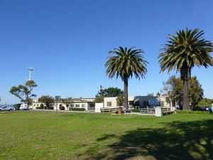
Most of the site is owned by the City of Rancho Palos Verdes, Los Angeles County, California. The city hall and other city facilities are located on the former military reservation.
|
{"selectable":false,"width":"500"} |
Location: City Hall, Rancho Palos Verdes, Los Angeles County, California. Maps & Images Lat: 33.7447911 Long: -118.4045523 |
Sources:
- U.S.Army, Supplement to the Harbor Defense Project Harbor Defenses of Los Angeles, (LA-AN-WDC-44), 31 Aug 1944, CDSG
Links:
Visited: 4 Jan 2013
Long Point Military Reservation Picture Gallery
|
Click on the picture to see a larger version. Contribute additional pictures - the more the better! |