Belleville Air Force Station
|
Belleville Air Force Station (1951-1968) - A Cold War U.S. Air Force Radar Station. Located near Belleville, St. Clair County, Illinois. Initially assigned a Permanent ID of P-70 and later a Sage ID of Z-70. The site was shared with the U.S. Army Nike missile-defense Army Air-Defense Command Post (AADCP) SL-47DC. Closed in 1968. HistoryEstablished in 1951 and became operational on 1 May 1951 as Belleville Air Force Station manned by the 798th AC&W Squadron, later named the 798th Radar Squadron (SAGE). Initial equipment included the FPS-3 search radar and CPS-4 height-finder radar. SAGE System TransitionThe transition of the manual GCI system to the automated SAGE system began with the installation of the FST-2 coordinate data transmitter and search radar upgrades. The FST-2 equipment digitized the radar returns and transmitted the digital returns to the SAGE direction center. Under the SAGE System, interceptor aircraft were directed to their targets by the direction center computers and controllers, greatly reducing the need for local controllers and equipment at every radar station. The FST-2 was a very large digital system using vacuum tube technology. Over 6900 vacuum tubes were used in each FST-2 requiring 21 air-conditioned cabinets, 40 tons of air conditioning, 43.5 kva of prime power, and usually a large new addition to the operations building. The FST-2B modification added two more cabinets but with newer solid-state (transistor) technology to process coded responses from aircraft transponders. SAGE System Operation
The site began operation as a SAGE site in 1961 initially feeding the Truax SAGE Direction Center DC-07. On 1 Mar 1962 the 798th AC&W Squadron was redesignated the 798th Radar Sq (SAGE). In 1963 the site was upgraded with a FPS-20 search radar and two FPS-6 height-finders. Circa 1966, the FPS-20 search radar was upgraded to become a FPS-66A. With the impending closure of the Truax SAGE Direction Center DC-07 on 31 Dec 1967, control of Belleville AFS was shifted to Sioux City SAGE Direction Center DC-22 on 1 Dec 1967 only to have that direction center scheduled for closure 18 Sep 1968. NIKE AADCPA U.S. Army NIKE System co-located their St. Louis Army Air Defense Command Post SL-47DC within the AC&W/SAGE operations building at Belleville AFS. The command post was established on 1 Jan 1960 and became operational in May 1960. The U.S. Army AADCP operated the BIRDIE (GSG-5) Nike control system at Bellville AFS and shared the long range radar data from the USAF radar sets. Overall control and track assignments were exercised from the Truax SAGE Direction Center DC-07 through U.S. Army channels. The Army air defense artillery director (ADAD) consoles and a field grade Army ADA battle staff officer at the SAGE Direction Center coordinated AADCP actions. ClosureBelleville AFS and the 798th along with the U.S. Army AADCP command post were deactivated on 18 Jun 1968; the station closed on 30 Jun 1968. Gap FillersBelleville AFS was responsible for the maintenance of two remote unattended gap-filler radar sites. The unattended gap filler sites were placed in locations where the main search radar lacked coverage. These sites were equipped with short range FPS-14 or FPS-18 search radars and FST-1 Coordinate Data transmitters that sent digitized radar target data to a SAGE direction center and to the main radar site. Both the radar set and the FST-1 were dual channel to increase site up time. Maintenance teams were dispatched for regularly scheduled maintenance or when fault indicators on the FSW-1 remote monitoring equipment suggested the site had problems. The FSW-1 also allowed remote operation of specific functions such as channel changes for the radar and for the FST-1, it also allowed remote operation of the diesel generators at the gap filler site. The Belleville AFS gap-filler radars were located at Bowling Green MO and Vichy MO. At least five gap-filler sites were contemplated with one other built but not activated at Marquand, MO. Some confusion over the Bowling Green site which may have earlier been contemplated as Edgewood MO (P-70B) site.
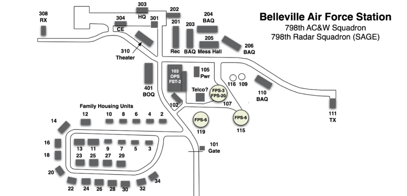
Physical Plant The physical plant of the site was divided into the main site, a cantonment area, a housing area and three radio sites. The main site housed the operations buildings, the radar towers, and the backup generators. The cantonment area housed the enlisted barracks, the bachelor officer's quarters, the orderly room, the dining hall, the motor pool and other support buildings. Apart from the main site was a small 27 unit housing area (originally just 9 units) for married personnel. A separate radio site housed the radio equipment for directing aircraft intercepts. Like most early radar stations, Belleville originally had a radio transmitter site and a separate radio receiver site used by local controllers for voice direction of fighter interceptors to their targets. With the SAGE System, the SAGE Direction centers had the primary task of directing intercepts and the local radio sites were reconfigured, usually into a single site that was known as the Ground to Air Transmitter Receiver (GATR) site. The GATR site communicated with the interceptors from either the local site or the SAGE direction center via voice commands and/or a digital data link. The Belleville AFS GATR site was located about 3/4 of a mile northeast of the main site.
Current StatusThe St. Clair Associated Vocational Enterprises (SAVE) has leased the old site for adult training.
See Also:
Sources:
Links:
Visited: No
|