Salisbury Beach Military Reservation
|
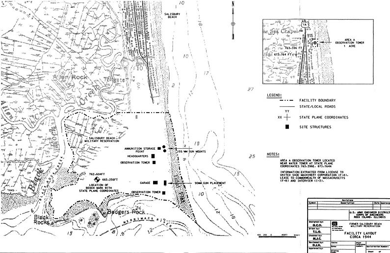
Salisbury Beach Military Reservation (1941-1945) - A World War II Coastal Military Reservation first established in 1941 in Essex County, Massachusetts. Deactivated and returned to the State of Massachusetts after 1945. World War II (1941-1945)Part of the Harbor Defense of Portsmouth, New Hampshire. Salisbury Beach Military Reservation was established by the War Department in 1941 on land leased from the State of Massachusetts. Two separate locations were established. The largest location, about 237 acres, was located on the north side of the mouth of the Merrimack River, south of the town of Salisbury Beach. The second site was about 1 acre and contained a fire control observation tower. The first site was closed and returned to the State of Massachusetts circa 1945-46. The second site was retained for a number of years. The larger site contained several World War II temporary buildings including a barracks, a mess hall, a BC station, and several magazines. The fire control station site was about 1.5 miles north of the main site and contained only a three story fire control station disguised as a summer cottage. The 1941 Boston Modernization Plan (Annex A) indicates that the Salisbury Beach Military Reservation at location 137B was a part of the Harbor Defenses of Boston but that site number is not reflected on later Boston supplements. That site number is reflected in the 1945 Portsmouth supplement but it shows only the smaller fire control site.

Current StatusPart of Salisbury Beach State Reservation, Essex County, Massachusetts. No period gun or mounts in place but Panama mounts may still be visible.
Sources:
Links:
Visited: No
| |||||||||||||||||||||||