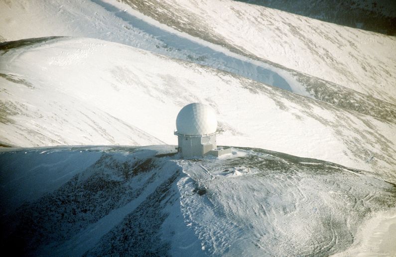
Sparrevohn Air Force Station
|
Sparrevohn Air Force Station (1951-Present) - A Cold War U.S. Air Force Station, part of the Alaska AC&W Radar Network. Initially functioned as a ground-control intercept (GCI) radar site, with a System ID of F-15. Named for Captain Frederic Sparrevohn who piloted the survey flight that selected the site. Later redesignated a surveillance site feeding manual track data to the King Salmon RCC. Became a minimally attended radar site in 1984 and was redesignated as Sparrevohn Long-Range Radar Site with a JSS ID of A-06. Now feeds radar track data to the FAA Anchorage ARTCC (ZAN) and to the Elmendorf NORAD Regional Air Operations Center (RAOC). Active Long-Range Radar Site (LRRS) with an FAA ID of ZSVW.
Sparrevohn AFS ConstructionIn 1951, when two gaps were discovered in the interior Alaska radar system coverage, there was a push to provide two ground-control intercept (GCI) sites to cover these areas that same year. The normal contracting and construction process would have delayed construction at least one year and perhaps two or three years given the short construction season in Alaska. The decision was made to build a minimal station using military personnel with scrounged funds and materials and then backfill with more permanent facilities using contractors. Military engineer construction personnel (813th Engineering Aviation Battalion) were selected to build the facility along with the first set of personnel who would man the radar site from the 531st Aircraft Control and Warning Group. The project was spearheaded by Major General William D. Old who personally selected the site on 3 Jun 1951. The 531st AC&W Gp. personnel was led by their commander Lt Colonel Fred A. Deyo. It was reported that General Old personally drove a D-8 bulldozer during the construction of the airstrip at the lower site. Operation of the site was later taken over by the 719th AC&W Squadron, activated in March 1954. Until the airstrip construction was complete, everything was airdropped including the D-8 bulldozer (in pieces). When completed, the 4,000-foot gravel airstrip was built on a 7% grade that ended in a mountain wall, landings were always uphill and takeoffs were always downhill and there was no room for error or opportunities for go-arounds. The 62nd Troop Carrier Wing (MATS) actually flew their aging three-story-high, four-engine Douglas C-124 Globemasters in and out of Sparrevohn. In 1978 a military C-130 crashed near the end of the runway at Sparrevohn killing all seven personnel on board. 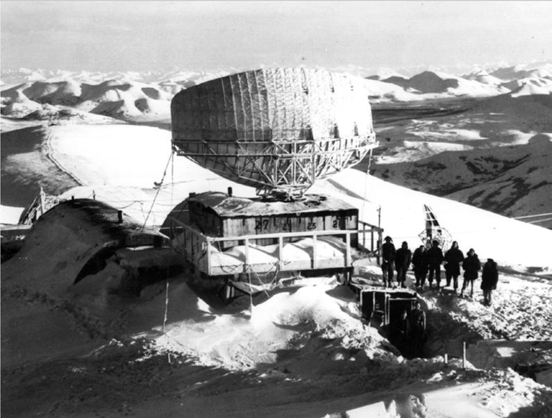 Men and equipment were airlifted to the site beginning in June 1951, and the site was operational on 13 Dec 1951, with a mobile CPS-5 radar. Five days later a 100 mph wind blew the unprotected antenna down and the need for radomes was established. When construction was completed a year later (December 1952), the AAC decided to replace the temporary facilities with permanent ones. The runway was improved, and a tramway connecting the top and bottom camps was completed in 1957 (remaining in operation until 1981). The cost of construction was $1.5 million. The lower camp was 1,500 feet below the upper camp on the mountaintop. A six-mile road with eleven switchbacks connected the upper and lower sites. The sharp corners made some truck drivers back up and turn at least twice for each one. The road was often impassable in the winter after a snowstorm. It was described in an Air Force Times article as a "man-killer" with 13 lives lost before it was closed in 1962. A second road was built that took a more roundabout track of 3.25 miles that was less dangerous. There were quarters at the top site and enough water, food, and fuel to last through the winter if necessary. When the contractors took over to complete the structures on the top site they had to rely on trucks to haul things up the switchback road. The contractors were forced to keep their trucks as light as possible because they all had to be airlifted in.
Sparrevohn AFS Operation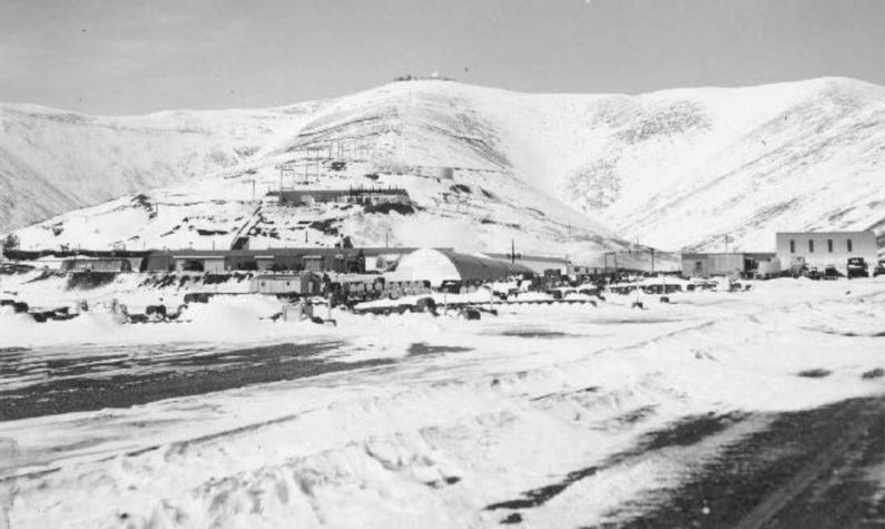 The mobile CPS-5D medium-range search radar was installed on the 3,400-foot mountaintop and became operational on 13 Dec 1951 without a protective radome. Five days later, winds estimated at 100 miles per hour blew down the antenna, demonstrating the need for radome protection. During 1953 an FPS-3 search radar on an arctic tower replaced the CPS-5 and later the CPS-4 was replaced by a FPS-6 height-finder. Later upgrades to the search radar included an upgrade to an FPS-20A by 1961 and that set was further upgraded to an FPS-93A configuration. An FPS-90 radar was added as a second height-finder. Aircraft track data from these radars was manually plotted on plotting boards and passed to the King Salmon Manual Direction Center on voice circuits. In 1965 the FYQ-9 Semiautomatic Data Processing and Display System was implemented on Alaska AC&W radar sites automating the passing of track data to the direction centers and combat centers. The result was reduced manpower requirements at the radar sites and increased efficiency. Further reductions came on 1 Oct 1977 when the Alaska Air Command (ACC) contracted with RCA Services for site support services. This was a part of an Air Force effort to reduce remote tours, many military positions were deleted leaving only 27 assigned and those were primarily in operations. JSS common digitizers were installed on the AC&W radars sites, including Sparrevohn, by 1982. This upgrade enabled transmission of radar track data via satellite to the new Elmendorf JSS Regional Operations Control Center (ROCC) near Anchorage. The Elmendorf ROCC was activated on 14 Jun 1983 and that event triggered a series of events that included the closure of the AC&W sites, the disbandment of the AC&W Squadrons, and the creation of Long-Range Radar Sites (LRRS) with full contractor operation and maintenance and new FPS-117 3D radars. The Sparrevohn AFS was deactivated on 1 Nov l983 even before the FPS-117 radars were installed.
Sparrevohn Long-Range Radar Site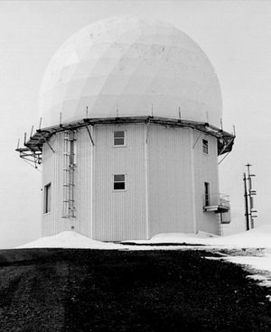 A new FPS-117 Minimally Attended Radar (MAR) was installed in Apr-Jun 1984 and the site was operational on 29 Jun 1984 and re-designated as Sparrevohn Long-Range Radar Site fully operated and maintained by contractors. The Long-Range radar site was connected to the Elmendorf JSS Regional Operations Control Center (ROCC) which was activated on 14 Jun 1983. The FPS-117 radar fed data to the ROCC FYQ-93 computers via satellite. The Elmendorf ROCC evolved into a Regional Air Operations Center (RAOC) which now operates with the Battle Control System-Fixed (BCS-F) FYQ-156 computer system. The RAOC is currently a component of the Alaska NORAD Region (ANR) and is operated by active Alaska Air National Guard members, Canadian servicemembers, and active duty augmentees. Elmendorf AFB is now a part of Joint Base Elmendorf-Richardson. By 2011 the MAR FPS-117 radars were outdated and increasingly unsupportable because parts and components were no longer available. In 2011 the U.S. Air Force awarded Lockheed Martin $46.8 million in contract options to begin modernization of 29 long-range radars. Under the EPRP contract, Lockheed Martin was to modernize 15 radars in Alaska including Sparrevohn. The last FPS-117 site was upgraded in June 2015. The EPRP program replaced four major subassemblies on the FPS-117: the Maintenance and Control System, the Beacon system, the Uninterruptable Power Supply/Communications Rack, and Local Control Terminals, which allow remote monitoring, troubleshooting, and control of the radars. The modifications reduced the line-replaceable unit count by approximately 80 percent, easing maintenance and the number of parts on the shelf. The program is expected to extend the supportably of the radar thru 2025.
Physical Plant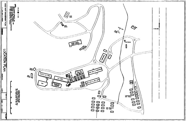 The physical plant of the site was originally divided into the main site, a cantonment area. The upper main site housed the radar towers, radar operations, the backup generators, upper site crew quarters and supplies. The cantonment area housed an operations area, the enlisted quarters (BAQ), the bachelor officer's quarters (BOQ), the orderly room, the dining hall and other support areas in a single large two-story composite building. The main power plant is located on the lower site but is also fed to the upper site. The upper site backup generator is available if the main power fails. No family housing was provided as this was considered a remote unaccompanied tour (1 year). 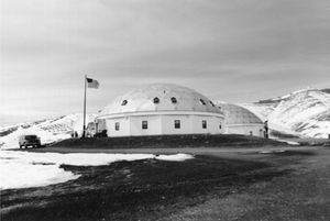 As manpower requirements reduced and contractors took over most of the functions, changes in the facilities were required. At four sites most of the AC&W facility was replaced with two aluminum domes - one dome for engineering and the second for housing. These domes were constructed at Sparrevohn, Indian Mountain, Cape Romanzof, and Tatalina.
Sparrevohn White Alice Communications SiteAfter HF systems proved inadequate for command and control communications, the Air Force implemented the White Alice Communications System (WACS). This was a system of tropospheric scatter and microwave radio relay sites constructed during the mid-1950s to provide reliable communications to Alaska Air Command (AAC) AC&W system. The Sparrevohn White Alice tropo site was built 1956-1957 and became operational on 26 Oct 1957. This station proved to be the most difficult WACS site to build because of the difficult terrain and because the area was so poorly known. The site was not accessible by land or water. This tropo station was linked with three other stations, Aniak, Tatalina, and Big Mountain. Construction included a 5,760 square-foot composite building and a sixteen-person, 5,200 square-foot dormitory. The 1960 modifications to the composite building cost in excess of $1.6 million. The specific links from Sparrevohn (SVW) as/of July 1977 were:
The Sparrevohn WACS was deactivated in May 1979 and replaced by an Alascom-owned satellite earth terminal that remains in service today.
Current StatusActive long-range radar site but most of the old AC&W site buildings have been demolished. The site has also had an environmental remediation project that has further erased signs of the old AC&W site and the White Alice tropo site. What remains is the FPS-117 Building on the upper site and the two domes on the lower site.
See Also:
Sources:
Links:
Visited: No
| ||||||||||||||||||||||||||||||||||||||||||||||||||||||
