Fort Loyal: Difference between revisions
Jump to navigation
Jump to search
John Stanton (talk | contribs) No edit summary |
John Stanton (talk | contribs) No edit summary |
||
| Line 3: | Line 3: | ||
{|{{FWpicframe}} | {|{{FWpicframe}} | ||
|- valign="top" | |- valign="top" | ||
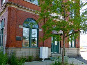
|width="50%"|[[Image:.jpg|300px|thumb|left|Fort Loyal]] | |width="50%"|[[Image:Fort Loyal - 2.jpg|300px|thumb|left|Fort Loyal Plaque Location]] | ||
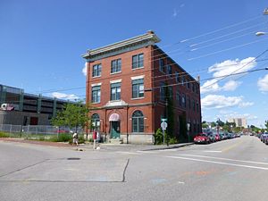
|width="50%"|[[Image:Fort Loyal - 5.jpg|300px|thumb|right|Fort Loyal Location on Portland Waterfront]] | |width="50%"|[[Image:Fort Loyal - 5.jpg|300px|thumb|right|Fort Loyal Location on Portland Waterfront]] | ||
|- | |- | ||
Revision as of 05:28, 25 June 2012
Fort Loyal (1680-1690) - Established as a colonial log palisaded fort in 1680 in present day Portland, Cumberland County, Maine. Captured by the French in 1690 and destroyed. Also known as Fort Loyall.
 |
 |
 | |
Fort Loyal History
Current Status
Plaque only, Cumberland County, Maine
|
{"selectable":false,"width":"500"} |
Location: Portland, Cumberland County, Maine. Maps & Images Lat: 43.659511 Long: -70.248191 |
Sources:
- Roberts, Robert B., Encyclopedia of Historic Forts: The Military, Pioneer, and Trading Posts of the United States, Macmillan, New York, 1988, 10th printing, ISBN 0-02-926880-X, page 367
Links:
Visited: 24 Jun 2012
Fort Loyal Picture Gallery
|
Click on the picture to see a larger version. Contribute additional pictures - the more the better! |