Almaden Air Force Station
|
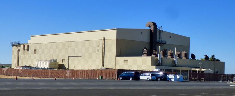
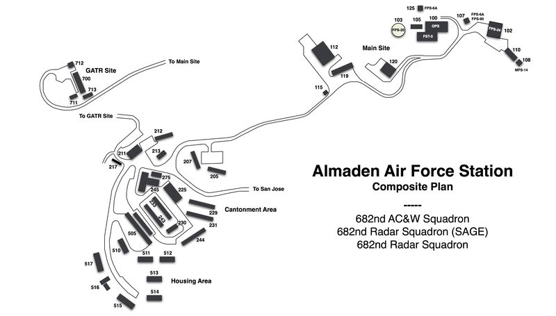
Almaden Air Force Station (1958-1980) - A Cold War Air Force Radar Station first established in 1958 on Mount Umunhum, Santa Clara County, California. Initially assigned a Permanent ID of M-96, later a Sage ID of Z-96. Abandoned in 1980. HistoryEstablished 24 Jun 1957 and became operational on 21 Mar 1958 as Almaden Air Force Station manned by the 682nd AC&W Squadron. The station initially had both a Ground-Control Intercept (GCI) and early warning mission. The early warning mission involved tracking and identifying all aircraft entering their airspace while the GCI mission involved guiding Air Force interceptors to any identified enemy aircraft. Controllers at the station vectored fighter aircraft at the correct course and speed to intercept enemy aircraft using voice commands via ground-to-air radio. Initial equipment in 1957 included the FPS-20 search radar and a single FPS-6A height-finder. The FPS-20 was located on an arctic type tower designated as building 103 just west of the operations building (Bldg 100). The antenna was enclosed in a radome. The FPS-6A was located on a temperate tower (Bldg 125) just north of the Operations Building. A second FPS-6A height-finder radar was also installed on a temperate tower (Bldg 107) in 1958. A new SAGE addition was built onto the operations building (Bldg 100) in 1959 and the FST-2 Coordinate Data Transmitter (CDT) was installed there in preparation for automated SAGE System operation. SAGE System TransitionThe transition of the manual GCI system to the automated SAGE system began with the installation of the FST-2 coordinate data transmitter and search radar upgrades. The FST-2 equipment digitized the radar returns and transmitted the digital returns to the SAGE direction center. Under the SAGE System, interceptor aircraft were directed to their targets by the direction center computers and controllers, greatly reducing the need for local controllers and equipment at every radar station. The FST-2 was a very large digital system using vacuum tube technology. Over 6900 vacuum tubes were used in each FST-2 requiring 21 air-conditioned cabinets, 40 tons of air conditioning, 43.5 kva of prime power, and usually a large new addition to the operations building. The FST-2B modification added two more cabinets but with newer solid-state (transistor) technology to process coded responses from aircraft transponders. SAGE System Operation
The site began operation as a SAGE site 1961 initially feeding the Beale SAGE Direction Center DC-18. ReconfigurationThe site was reconfigured in 1962-1963 to support a new long-range search radar, the FPS-24. The FPS-24 was housed in a four-story concrete building (Bldg 102) east of the Operations building. The FPS-6A height-finder radar in building 107 was upgraded to an FPS-90 in the spring of 1963. A MPS-14 mobile height-finder radar was placed in a temperate tower designated as building 108. At the end of the reconfiguration, the site had an FPS-24 search radar (Bldg 102), an FPS-90 height-finder (Bldg 107) and an MPS-14 height-finder (Bldg 108). The remaining FPS-20 and FPS-6A radars and towers were removed (Buildings 103 and 125). The new search radar interfered with the operation of the Ground to Air Transmitter/Receiver (GATR) site located nearby in building 110. The GATR site was relocated to nearby Mount Thayer. When the Beale SAGE Direction Center DC-18 closed in 1963 Almaden AFS was connected to the Norton SAGE Direction Center DC-17 until it closed in 1966. Control of Almaden AFS then shifted to Adair SAGE Direction Center DC-13 until it closed in 1969 and finally to Luke SAGE Direction Center DC-21. The FST-2B was replaced with a more up-to-date coordinate data transmitter, the solid state FYQ-47 in May 1972. The FPS-90 height-finder radar was deactivated on 1 Oct 1976 and removed. ClosureAlmaden AFS and the 682nd were deactivated on 1 Apr 1980.
Physical PlantThe physical plant of the site was divided into the main site, a cantonment area, a housing area and a radio site. The main site housed the operations buildings, the radar towers, and the backup generators. The cantonment area was below the main site and housed the enlisted barracks, the bachelor officer's quarters, the orderly room, the dining hall, the motor pool and other support buildings. Just below the cantonment area was a small 27 unit housing area for married personnel. Leased housing units were also available in San Jose. A separate Ground to Air Transmitter/Receiver (GATR) radio site on nearby Mount Thayer housed the radio equipment for directing aircraft intercepts. The original GATR site was relocated to Mount Thayer because of interference from the high powered FPS-24 radar. 
Current StatusPart of the Sierra Azul Open Space Preserve but not open to the public. The opening has been rescheduled for 2017. Except for the FPS-24 tower the main site has been leveled.
See Also:
Sources:
Visited: No
|