Fort Fisher Air Force Station
|
Fort Fisher Air Force Station (1955-1988) - A Cold War Air Force Radar Station first established in 1955 near Kure Beach, New Hanover County, North Carolina. Named Fort Fisher Air Force Station after the location. Initially assigned a Permanent ID of M-115, later a Sage ID of Z-115 and a JSS ID of J-02. Abandoned in 1988 and part turned over to the FAA with the remainder being used by the Fort Fisher Recreation Center and the North Carolina National Guard. The FAA area is now known as Fort Fisher FAA Radar Site with an FAA ID of QGV.
HistoryEstablished on 1 Aug 1955 and became operational in 1955 as Fort Fisher Air Force Station manned by the 701st AC&W Squadron. The station initially had both a Ground-Control Intercept (GCI) and early warning mission. The early warning mission involved tracking and identifying all aircraft entering their airspace while the GCI mission involved guiding Air Force interceptors to any identified enemy aircraft. Controllers at the station vectored fighter aircraft at the correct course and speed to intercept enemy aircraft using voice commands via ground-to-air radio. Initial equipment included the MPS-7 search radar and an MPS-8 height-finder radar. SAGE System TransitionThe transition of the manual GCI system to the automated SAGE system began with the installation of the FST-2 coordinate data transmitter and search radar upgrades. The FST-2 equipment digitized the radar returns and transmitted the digital returns to the SAGE direction center. Under the SAGE System, interceptor aircraft were directed to their targets by the direction center computers and controllers, greatly reducing the need for local controllers and equipment at every radar station. The FST-2 was a very large digital system using vacuum tube technology. Over 6900 vacuum tubes were used in each FST-2 requiring 21 air-conditioned cabinets, 40 tons of air conditioning, 43.5 kva of prime power, and usually a large new addition to the operations building. The FST-2B modification added two more cabinets but with newer solid-state (transistor) technology to process coded responses from aircraft transponders. SAGE System Operation
The site began operation as a SAGE site in 1961 initially feeding the Fort Lee SAGE Direction Center DC-04. The search radar was upgraded to an FPS-7C and an FPS-26A height-finder radar was installed. The FPS-26A later became an FSS-7 SLBM detecting radar operated by Det 5, 14 MWS. The FPS-7C was later modified to become an FPS-107V Gap Filler RadarsFort Fisher AFS was responsible for the maintenance of three remote unattended gap-filler radar sites. The unattended gap filler sites were placed in locations where the main search radar lacked coverage. These sites were equipped with short range FPS-14 or FPS-18 search radars and FST-1 Coordinate Data transmitters that sent digitized radar target data to a SAGE direction center and to the main radar site. Both the radar set and the FST-1 were dual channel to increase site up time. Maintenance teams were dispatched for regularly scheduled maintenance or when fault indicators on the FSW-1 remote monitoring equipment suggested the site had problems. The FSW-1 also allowed remote operation of specific functions such as channel changes for the radar and for the FST-1, it also allowed remote operation of the diesel generators at the gap filler site. The Fort Fisher AFS gap-filler radars were located at Myrtle Beach SC, Fort Bragg NC, and Holly Ridge NC.
BUIC SystemFort Fisher AFS became a BUIC I GCI site on 15 Jan 1963. It was selected as a BUIC III site and became the first operational BUIC III site. In 1970 the 701st Radar Squadron (SAGE) became the 701st Air Defense Group (BUIC). The BUIC III system provided a backup for a SAGE direction center and provided the ability to display sector-wide radar data on consoles for local weapons controllers. The system duplicated the functionality of the vacuum tube direction center computers with the more up-to-date GSA-51 computer system and replaced the FST-2 with a more up-to-date coordinate data transmitter, the FYQ-47. As the threat from a Soviet bomber fleet lessened the decision came to mothball the BUIC system in 1974. ClosureFort Fisher AFS and the 701st were deactivated on 30 Jun 1988. Fort Fisher FAA Radar SiteUpon deactivation, the FAA assumed operation of a part of the old Fort Fisher AFS as JSS site J-02 and Fort Fisher FAA Radar Site. An FPS-91A search radar was installed in the old FPS-26A /FSS-7 tower. A FPS-116 height-finder had been installed in the FPS-107 tower until it was retired about 1988. It is not known if the FYQ-47 common digitizer was changed out for a CD-2 Common Digitizer. The original site was deactivated altogether when a new ARSR-4 radar was installed and commissioned at the former GATR site. The new ARSR-4 site was in place by February 1998 (as shown in historical satellite photos). The ARSR-4 and an ATCBI-6M Beacon set are now in operation at the FAA Radar Site. The radar site data is now available to the USAF/NORAD Battle Control System-Fixed (BCS-F) operations centers (EADS & WADS) as well as the FAA Washington DC ARTCC (ZDC) and adjacent ARTCCs. Other federal agencies have access to the data under the Homeland Security umbrella. Physical Plant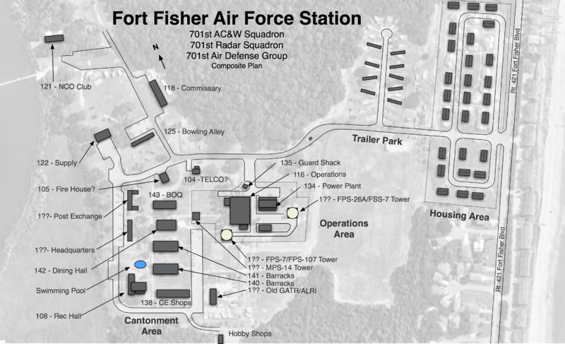 The physical plant of the site was divided into the main operations site, a cantonment area, a housing area, a trailer park, and a radio site. The main operations site housed the operations buildings, the radar towers, and the backup generators. The cantonment area housed the enlisted barracks, the bachelor officer's quarters, the orderly room, the dining hall, the motor pool, a post exchange, a small commissary, and other support buildings. Apart from the main site was a small 27 unit housing area for critical married personnel and an adjacent 23 unit trailer park. There were also some 26 leased government quarters in Wilmington and Carolina Beach. A separate Ground to Air Transmitter/Receiver (GATR) radio site housed the radio equipment for directing aircraft intercepts. The GATR site is now the location of the FAA ARSR-4 radar site known as Fort Fisher FAA Radar Site.
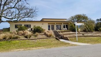
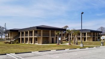
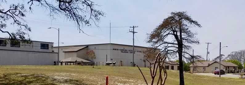
Current Status  Abandoned as a radar site and now part of the Fort Fisher Air Force Recreation Area in Kure Beach, New Hanover County, North Carolina. Many of the original radar site buildings remain, some are in use by the North Carolina National Guard as a training center and the remainder is connected to the recreation area. In the old operations area, the operations building, the powerhouse and the security building remain but all signs of the three radar towers are gone. In the cantonment area, the Rec Hall, C-E Maintenance, two dorms, the Dining Hall, BOQ, Supply, and the Commissary buildings remain but some have been significantly altered, upgraded and repurposed. The old two-lane bowling alley is now a museum. The two enlisted dorms have been extensively changed or perhaps rebuilt and have a motel look with exterior entrances to individual rooms. Gone are the HQ building and the BX building. The BOQ building is now known as the "River Marsh" building. The original housing area was built in two phases like most AC&W sites with the original 9 units south of Riverfront Road and the later 18 units north of River Front Road. The older set of 9 remains as they were built but updated, the later set of 18 has been replaced with beach type cottages.
See Also:
Sources:
Links: Visited: 16 Mar 2016
| |||||||||||||||||||||||||||||||||||||||||||||||||||||||||||||||||||||||||||||||||||||||||||||||||||||||||||||||||||||||||||||||||||||||||||||||||||||||||||||||||||||||||||||||||||||||||||||||||||||||||||||||||||||||
- FST-2
- SAGE Radar Sites
- FSW-1
- Visited
- All
- North Carolina All
- North Carolina Radar Sites
- North Carolina New Hanover County
- Fort Fisher Air Force Station
- 2018 Research Trip
- Starter Page
- USAF Radar Sites
- BUIC Sites
- SAGE Sites
- JSS Sites
- JSS Sites Original
- JSS Sites Military
- SLBM Detection Radar Sites
- MPS-7
- FPS-7
- FPS-107
- MPS-8
- MPS-14
- FPS-26
- FSS-7
- FYQ-47
- GSA-51
- FPS-14
- FPS-18
- FST-1
- UPX-14
- GPA-124
- GPA-127
- GKA-5
- KWT-6
