Fort Townsend: Difference between revisions
John Stanton (talk | contribs) No edit summary |
Bot: Automated import of articles *** existing text overwritten *** |
||
| (30 intermediate revisions by 2 users not shown) | |||
| Line 1: | Line 1: | ||
{{SocialNetworks}} | {{SocialNetworks}} | ||
[[Image:FortTownsend 1885 UW.jpg|thumb| | {{PageHeader}}{{External|wikidata=Q1438765|wikipedia=Fort_Townsend_State_Park}} | ||
'''Fort Townsend (1856-1861) (1874-1895)''' - Fort Townsend was established in 1856 by Bvt. Major [[Granville O. Haller]]<!-- not USMA -->, [[4th U.S. Infantry]], U.S. Army, for the protection of settlers during the [[Yakima War|Yakima Indian War]]. | |||
{|{{FWpicframe}} | |||
|- valign="top" | |||
|width="50%"|[[Image:FortTownsend 1885 UW.jpg|thumb|385px|left|Barracks at Fort Townsend circa 1885 (University of Washington Archive)]] | |||
|width="50%"|[[Image:FortTownsend GuardHouse 1885 UW.jpg|thumb|right|350px|Guardhouse at Fort Townsend circa 1885 (University of Washington Archive)]] | |||
|- | |||
|colspan="2"|[[File:Fort Townsend15-10.jpg|thumb|center|795px|Fort Townsend Parade & Flagpole]] | |||
|} | |||
== Fort Townsend == | |||
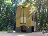
[[File:Fort Townsend15-12.jpg|thumb|left|200px|Fort Townsend WWII Navy Explosives Laboratory for Defusing Enemy Mines and Torpedos]] | |||
Fort Townsend was first established on 26 Oct 1856 by Major Haller as a blockhouse for settler protection during the [[Yakima War|Yakima Indian War]]. In 1859 troops were sent from the fort to [[American Camp]] to assist in the San Juan Island boundary dispute commonly known as "The [[Pig War]]." The fort was placed in caretaker status between 1859 and 1874 for being "unfit," after an inspection by General [[William S. Harney]]<!-- not USMA -->, Commander of the army headquarters in Columbia. Brought back to life in 1874, the fort thrived until 1895 when fire - started by an exploding kerosene lamp - destroyed the barracks. The fort was decommissioned but was used during [[World War II]] as enemy munitions defusing station. In 1958 it was turned over to the State Parks Commission. | |||
{{Clr}} | {{Clr}} | ||
== Current Status == | |||
Old Fort Townsend State Park, Jefferson County, Washington. Not much of the Fort remains except the grounds and a flagpole. Interpretive signs mark the locations of important buildings and places but nothing remains that can be viewed. The WWII Navy Explosives Laboratory building is located on the road coming into the fort site. | |||
---- | ---- | ||
{| | {| | ||
| | | | ||
<googlemap lat="48.07628" lon="-122.78789" zoom="16" width="500" | <googlemap version="0.9" lat="48.07628" lon="-122.78789" zoom="16" width="-500" height="-500" scale="yes" overview="yes" controls="large" icons="http://www.fortwiki.com/mapicons/icon{label}.png"> | ||
(F) 48.07628, -122.78789, Fort | (F) 48.07628, -122.78789, Fort Townsend | ||
(1856-1861)<br>(1874-1895) | |||
</googlemap> | </googlemap> | ||
|valign="top"| | |valign="top"| | ||
'''Location:''' On the Olympic Peninsula, approximately two miles south of Port Townsend. | '''Location:''' On the Olympic Peninsula, approximately two miles south of<br>Port Townsend, Jefferson County, Washington. | ||
{{Mapit-US-cityscale|48.07628|-122.78789}} | {{Mapit-US-cityscale|48.07628|-122.78789}} | ||
* Elevation: | * Elevation: 194' | ||
|valign="top"| | |||
<br><br> | |||
'''GPS Locations:''' | |||
* {{GPSLinkLong|Lat=48.07628|Lon=-122.78789}} Fort Townsend | |||
|} | |} | ||
'''See Also:''' | |||
* [[:Category:Washington Blockhouses|Washington Blockhouses]] | |||
'''Sources:''' | |||
* {{Roberts}}, page 837 | |||
* {{Hart}}, page 189-190 | |||
* {{Whiting}}, page 105 | |||
* {{McDaniel}}, page 253 | |||
'''Links:''' | '''Links:''' | ||
*[http://www.parks.wa.gov/ | * [http://www.northamericanforts.com/West/wa.html#towns North American Forts - Fort Townsend] | ||
*[http:// | * [http://www.parks.wa.gov/parks/?selectedpark=Fort%20Townsend Old Fort Townsend State Park] | ||
* [http://www.historylink.org/index.cfm?DisplayPage=output.cfm&file_id=10087 History Link - Fort Towsend] | |||
{{FortID|ID=WA0307|Name={{PAGENAME}}}} | |||
{{Visited|17 Aug 2022, 26 Aug 2015, 19 Jul 2008}} | |||
==Picture Gallery== | ==Picture Gallery== | ||
<gallery> | <gallery> | ||
Image:FortTownsend Barracks 1885 UW.jpg|Fort Townsend Barracks Interior circa 1885 (University of Washington Archive) | Image:FortTownsend Barracks 1885 UW.jpg|Fort Townsend Barracks Interior circa 1885 (University of Washington Archive) | ||
</gallery> | </gallery> | ||
__NOTOC__ | __NOTOC__ | ||
{{PageFooter}} | |||
{{DEFAULTSORT:Townsend}} | {{DEFAULTSORT:Townsend}} | ||
[[Category:All]] | [[Category:All]] | ||
[[Category:Washington All]] | [[Category:Washington All]] | ||
[[Category:Washington Forts]] | [[Category:Washington Forts]] | ||
[[Category:Washington Blockhouses]] | |||
[[Category:Washington Jefferson County]] | |||
[[Category:Coastal Forts]] | [[Category:Coastal Forts]] | ||
[[Category:{{PAGENAME}}]] | [[Category:{{PAGENAME}}]] | ||
[[Category:2015 Research Trip]] | |||
[[Category:2022 Research Trip]] | |||
Latest revision as of 05:04, 26 February 2025
| More information at Warlike, Wikipedia
Fort Townsend (1856-1861) (1874-1895) - Fort Townsend was established in 1856 by Bvt. Major Granville O. Haller, 4th U.S. Infantry, U.S. Army, for the protection of settlers during the Yakima Indian War.
Fort Townsend Fort Townsend was first established on 26 Oct 1856 by Major Haller as a blockhouse for settler protection during the Yakima Indian War. In 1859 troops were sent from the fort to American Camp to assist in the San Juan Island boundary dispute commonly known as "The Pig War." The fort was placed in caretaker status between 1859 and 1874 for being "unfit," after an inspection by General William S. Harney, Commander of the army headquarters in Columbia. Brought back to life in 1874, the fort thrived until 1895 when fire - started by an exploding kerosene lamp - destroyed the barracks. The fort was decommissioned but was used during World War II as enemy munitions defusing station. In 1958 it was turned over to the State Parks Commission.
Current StatusOld Fort Townsend State Park, Jefferson County, Washington. Not much of the Fort remains except the grounds and a flagpole. Interpretive signs mark the locations of important buildings and places but nothing remains that can be viewed. The WWII Navy Explosives Laboratory building is located on the road coming into the fort site.
See Also: Sources:
Links: Fortification ID:
Visited: 17 Aug 2022, 26 Aug 2015, 19 Jul 2008 Picture Gallery
| |||||||


