North Truro Air Force Station
|
North Truro Air Force Station (1951-1985) - A Cold War Air Force Radar Station first established in 1951 on Cape Cod, Barnstable County, Massachusetts. Named North Truro Air Force Station after the location. Initially assigned a Permanent ID of P-10 and later a Sage ID of Z-10, a JSS ID of J-53, and an FAA ID of QEA. The Air Force Station was decommissioned in 1985 and partly turned over to the FAA and the remainder to the National Park Service. Now known as North Truro FAA Radar Site.
History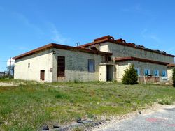 Established in 1951 and became operational as North Truro Air Force Station manned by the 762nd AC&W Squadron. The station initially had both a Ground-Control Intercept (GCI) and early warning mission. The early warning mission involved tracking and identifying all aircraft entering their airspace while the GCI mission involved guiding Air Force interceptors to any identified enemy aircraft. Controllers at the station vectored fighter aircraft at the correct course and speed to intercept enemy aircraft using voice commands via ground-to-air radio. Initial equipment included two CPS-3 transportable search radar.
SAGE System Transition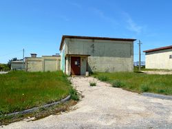 The transition of the manual GCI system to the automated SAGE system began with the installation of the FST-2 coordinate data transmitter and search radar upgrades. The FST-2 equipment digitized the radar returns and transmitted the digital returns to the SAGE direction center. Under the SAGE System, interceptor aircraft were directed to their targets by the direction center computers and controllers, greatly reducing the need for local controllers and equipment at every radar station. The FST-2 was a very large digital system using vacuum tube technology. Over 6900 vacuum tubes were used in each FST-2 requiring 21 air-conditioned cabinets, 40 tons of air conditioning, 43.5 kva of prime power, and usually a large new addition to the operations building. The FST-2B modification added two more cabinets but with newer solid-state (transistor) technology to process coded responses from aircraft transponders.
SAGE System Operation
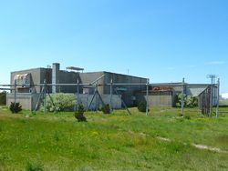 The site began operation as a SAGE site in 1958 initially feeding the Stewart SAGE Direction Center DC-02 at Stewart AFB. With the closure of DC-02 in 1966 North Truro was connected to the Hancock SAGE Direction Center DC-03 at Hancock Field. In 1960 the search radar was upgraded to an FPS-7 and two FPS-6 height-finders were installed. The FPS-7 search radar was later upgraded to become an FPS-107. In 1963 one of the FPS-6 height-finders was modified to become an FPS-90 while the other was replaced by an FPS-26A. The FPS-90 was modified to become an FPS-116 circa 1977 and the FPS-26A was totally removed early in 1979.
Texas Tower 2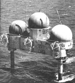 Texas Tower 2 (TT-2) was an important part of the North Truro AFS mission in the late 1950s and early 1960s because it served to support tower personnel, logistics and served as the terminal for communications from the tower. The tower was built of steel with three decks in a triangular shape. Supporting the tower were three legs that anchored it to the ocean floor. Tower two was floated out to Georges bank arriving about 15 Jul 1955. TT-2 had three decks, the two lower decks housed the mechanical equipment and the crew quarters. Most of the top deck (weather deck) was devoted to a helicopter landing area and two large cranes. One side of the weather deck, enclosed in a 210' by 60' structure, was the operations area, radar, FST-2, and communications gear. Atop that structure were the three radar sets with antennas enclosed in protective bubbles. On 7 May 1957, the tower was declared operational on a limited basis. On 17 Apr 1958, it was declared fully operational in a manual mode. In September 1958 TT-2 became SAGE system operational feeding digitized radar data by tropospheric radio system, FRC-56 to North Truro AFS and from there by landline to the Stewart SAGE Direction Center DC-02. Communications with the shore were through the tropospheric radio system, FRC-56. The landside FRC-56 terminal was located at North Truro AFS and through it passed all the data and voice communication circuits to and from TT-2. TT-2 was decommissioned on 15 Jan 1963. Salvageable equipment was removed and a salvage company then dynamited the three legs hoping to float the upper structure to the shore. Instead of floating the structure sank and was not recoverable.
ALRI System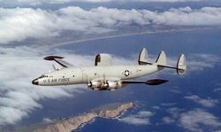 In 1962 an Airborne Long Range Inputs (ALRI) ground facility was commissioned at North Truro AFS to process ALRI data from EC-121 Airborne radar aircraft stationed at Otis AFB (551st Airborne Early Warning and Control Wing). This radar-equipped aircraft few fixed stations 300 miles out over the Atlantic to extend the range of land-based radar coverage and to supplement the Texas Towers coverage. When the Texas Towers closed, they replaced the coverage. The ALRI Facility received radar data from the planes and sent it into the SAGE System.
BUIC System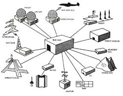 North Truro AFS played a significant role in the development of the BackUp Interceptor Control (BUIC) program. The BUIC program came about as budget cuts forced the closure of radar sites and SAGE direction centers. The BUIC concept allowed the BUIC equipped sites to take over the functionality of one or more direction centers should they become inoperative. This capability was to have been achieved by adopting more advanced computer systems and software but it also required each BUIC site to have a full complement of highly trained weapons controllers, a very expensive proposition. At the same time the threat from manned bombers was reduced and the vulnerability of radar sites and direction centers increased. In 1974 all of the BUIC III capability was mothballed except the site at Tyndall AFB, Florida. North Truro was the first BUIC II site activated and first radar station to be designated a BUIC III site. BUIC operations ended at North Truro AFS in 1974.
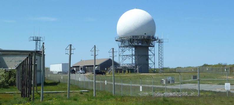
Air Force Station ClosureNorth Truro AFS was decommissioned in a 14 Jun 1985 ceremony at the station. A small part of the property was transferred to the FAA and is operated by the FAA as the North Truro FAA Radar Site. North Truro FAA Radar Site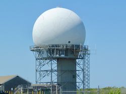 This FAA radar site was established on the closure of North Truro Air Force Station in 1985. The initial search radar was an FPS-91A and the Air Force FPS-107 was removed. After the Air Force station closed the FPS-116 height-finder radar remained operational until it was removed circa 1988. A FYQ-47 Common Digitizer was probably placed in service by February 1973 when the USAF/FAA FST-2 to FYQ-47 replacement program was completed. By 1990 the site was equipped with an FPS-91A search radar and a CD-2C Common Digitizer. The North Truro CD-2C was scheduled to receive an upgrade kit to implement three level weather data processing in September 1992. A new ARSR-4 3D search radar was installed between 1996 and 1999. Construction was underway on the ARSR-4 tower and dome in October 1994 when it was put on hold by the FAA over local concerns about the location, design and health risks. Construction resumed after the concerns were addressed and the site currently operates the ARSR-4 3D radar and an ATCBI-6M Beacon system. The radar site data is now available to the USAF/NORAD Battle Control System-Fixed (BCS-F) operations centers (EADS & WADS) as well as the FAA
Boston ARTCC (ZBW) and adjacent ARTCCs. Other federal agencies have access to the data under the Homeland Security umbrella.
Gap FillersNorth Truro AFS was responsible for the maintenance of three remote unattended gap-filler radar sites. The gap-filler sites were placed in locations where the main search radar lacked coverage. These sites sent digitized radar target data directly to a direction center. Maintenance teams were dispatched from North Truro AFS for regularly scheduled maintenance or when fault indicators suggested the site had problems. North Truro was responsible for gap-filler sites at Westboro and Chilmark Massachusetts and the site at Fort Dearborn, New Hampshire.
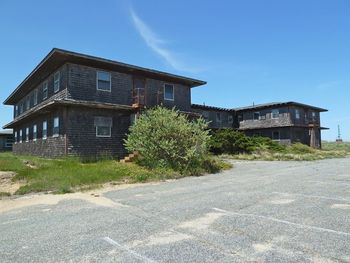
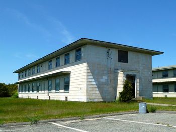
Physical PlantThe physical plant of the site was divided into the main site, a housing area, a radio site, and a troposcatter communications site. The main site housed two operations buildings (AC&W & SAGE), the radar towers, the enlisted barracks, the bachelor officer's quarters, the orderly room, the chow hall, the motor pool, and the backup generators. Apart from the main site was a small 27 unit housing area for married personnel. A separate radio site housed the radio equipment for directing aircraft intercepts. A troposcatter communications site was used for communications with Texas Tower 2, a radar platform 90 miles out in the Atlantic. 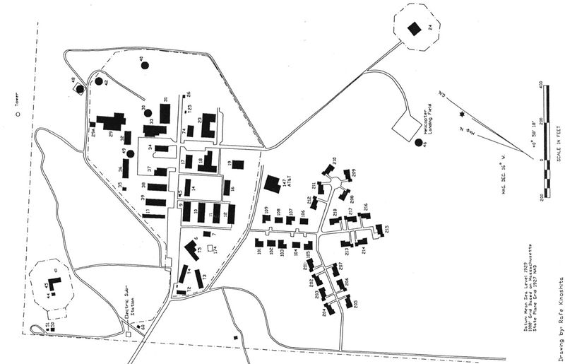
Current Status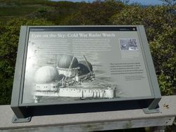 A small part of the property was transferred to the FAA and that now houses their ARSR-4 Radar. The remainder of the site, including most of the buildings, was transferred to the National Park Service in 1994 and is now part of the Cape Cod National Seashore.
Current Status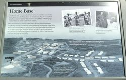 Part of the Cape Cod National Seashore administered by the National Park Service on Cape Cod, Barnstable County, Massachusetts. Most of the buildings are still standing but closed. Several interpretive signs are located on the site.
See Also:
Sources:
Links:
Visited: 3 May 2018, 17 May 2012 | ||||||||||||||||||||||||||||||||||||||||||||||||||||||||||||||||||||||||||||||||||||||||||||||||||||||||||||||||||||||||||||||||||||||||||||||||||||||||||||||||||||||||||||||||||||||||||||||||||||||||||||||||||||||||||||||||||||||||||||||||||||||||||||||||||||||||||||||||||||||||||||||||||||||||||||||||||||||||||||||||||||||||||||||||||||||||||||||||||||||||||||||||||||||||||||||||||||||||||||||||||||||||||||||||||||||||||||||||||||||||||||||||||||||||||||||||||||||||||||||||||||||||||||||||||||||||||||||||||||||||||||||||||||||||
- FST-2
- SAGE Radar Sites
- Visited
- All
- Massachusetts All
- Massachusetts Radar Sites
- Massachusetts Barnstable County
- North Truro Air Force Station
- Starter Page
- USAF Radar Sites
- 2012 Research Trip
- 2018 Research Trip
- BUIC Sites
- SAGE Sites
- JSS Sites
- JSS Sites Original
- JSS Sites Military
- CPS-3
- FPS-8
- GPS-3
- CPS-6
- FPS-7
- FPS-107
- FPS-91
- FPS-6
- FPS-90
- FPS-26
- FPS-116
- GSA-51
- FPS-14
- FST-1
- FYQ-47
- FRC-56
- GKA-5
- UPX-14
- UPA-35
