Half Moon Bay WWII Radar Site
|
Half Moon Bay WWII Radar Site (1942-1951) - A World War II U.S. Army Radar Site established in 1942. Used to provide early warning of enemy aircraft approaching the California Coast. Located on Half Moon Bay near the Town of Half Moon Bay in San Mateo County, California. Deactivated in 1951. Also known as Station L-82 Half Moon Bay Tactical Position and later Half Moon Bay Lashup Radar Site.
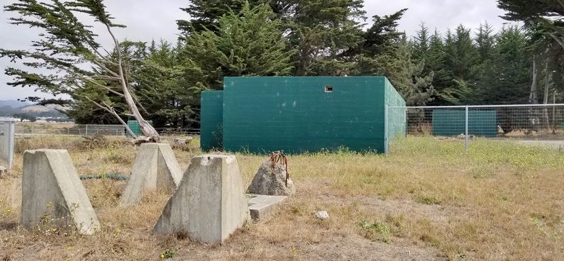
Half Moon Bay WWII Radar Site L-82This radar site was established during World War II early in 1942 as a part of a chain of radar stations along the West Coast of the United States and Canada. These secret radar sites were built to provide early warning of approaching enemy aircraft and ships but also served to assist friendly aircraft that were lost or had in-flight emergencies. Plan drawings of the cantonment area of the Half Moon Bay radar site in 1945 appears to show four barracks style buildings with two of them identified as barracks and the other two not identified. The cantonment area also housed a large mess hall, a recreation building, a gate security shack, a latrine, a bathhouse and some small support buildings. The latrine was sized for 65 officers and enlisted men with four commodes, one of which was in a separate room for officers. The cantonment buildings were temporary "Theater of Operations" style buildings not meant to last much beyond the duration of the war. The operations area is shown on the plan with just two buildings, an operations building and a power building. Both of these buildings were heavy reinforced concrete construction with offset entrances for protection. The power building was built for three generators. Just west of the operations building are the four concrete footings for the SCR-588-B antenna. Post WWII OperationPostwar, the Fourth Air Force continued to operate at Half Moon Bay with Site L-82 serving as an IFF and training station with plans to replace the SCR-588-B with a CPS-1 if it showed an improvement over the SCR-588-B. On 20 May 1947 operation of Half Moon Bay radar site fell to a detachment of the 636th AC&W Squadron. On 24 July 1947, the southern portion of the reservation was declared surplus and the property returned to the owners on 15 Aug 1948. This property included the site of Direction Finding Station 4K5 which was deactivated. On 18 Sep 1947 the U.S. Air Force became a separate service and assumed responsibility for the radar network that no longer existed. At the end of 1947 Air Defense Command (ADC) had only two operational radar sites, one at Arlington in Washington State and the other at Half Moon Bay, California. Both these sites worked with fighter squadrons to perfect ground-control and interception techniques for the new radar network in the planning stages. (Winkler, P. 16). On 2 Jan 1948, the headquarters of the 636th AC&W Squadron moved from Hamilton Air Force Base to Half Moon Bay. The squadron then oversaw dismantling of radar stations at Olema, Gualala and Carmel, California. At that time Half Moon Bay had CPS-1, SCR-588-B, TPS-10 radar sets and CPA-7 Radar Operations Room equipment. Later In January of 1948 the SCR-588-B radar set was removed and shipped to McClellan Air Force Base. On 15 Sep 1948, the 636th AC&W Squadron transferred to Kirkland Air Force Base, New Mexico leaving a detachment to operate the radar and the Air Defense Direction Center (ADDC) at Half Moon Bay. The detachment was designated Detachment G. The squadron took a TPS-10 radar set with them and left two TPS-1B radar sets and two BN-2 IFF sets at Half Moon Bay. The Half Moon Bay Detachment ended up with a TPS-10 radar, a CPS-1 radar and a CPX-1 IFF set. The unit had subordinate detachments in standby at Palos Verdes, Berkeley and La Jolla, California. By 1948 the Site's WWII temporary cantonment buildings had deteriorated and were described as "deplorable" by the detachment commander.
Half Moon Bay Lashup Radar Site L-38In February 1950, the ADDC was removed to Mather Air Force Base in Sacramento and the 668th AC&W left a detachment to operate the CPS-5 radar set at Half Moon Bay. In June 1950, the Site was incorporated into the temporary Lashup system as site L-38 with the installation of a CPS-6 radar set.
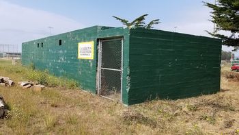
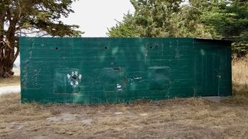
ClosureIn October 1951, Mill Valley Air Force Station became operational and assumed the coverage of the Lashup site L-38 at Half Moon Bay. The Lashup site shut down and the U.S. Air Force declared the site surplus, terminating the three remaining leases in 1952. Current StatusThe north part of the site is now part of the Half Moon Bay park system. Two buildings and the concrete footings for the SCR-588-B antenna tower remain on the north part of the original site. The south side of the site appears to be in private hands with one original concrete building (probably the Direction Finding Station 4K5) remaining. On the east side, Cameron's Inn and Restaurant occupies the footprint of the cantonment mess hall and perphaps still contains some of the structure
See Also: Sources:
Links: Visited: 6 Sep 2017
| |||||||


