Fort Casey (1): Difference between revisions
John Stanton (talk | contribs) No edit summary |
John Stanton (talk | contribs) No edit summary |
||
| Line 1: | Line 1: | ||
{{SocialNetworks}} | {{SocialNetworks}} | ||
'''Fort Casey ( | '''Fort Casey (1890-1950)''' - In 1890 the Army established its garrison at Fort Casey named in honor of Brigadier General [[Thomas Lincoln Casey]], the last U.S. Army chief of engineers. | ||
{{Clr}} | {{Clr}} | ||
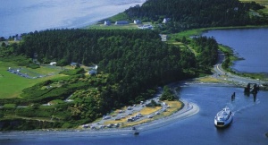
[[Image:FortCasey.jpg|thumb|300px|left|Fort Casey]] | [[Image:FortCasey.jpg|thumb|300px|left|Fort Casey]] | ||
| Line 7: | Line 7: | ||
Fort Casey, with [[Fort Worden]] and [[Fort Flagler]], comprised a "triangle of fire" guarding the entrance to Puget Sound. All the guns were removed from Fort Casey prior to it's abandonment by the US Army in 1950. | Fort Casey, with [[Fort Worden]] and [[Fort Flagler]], comprised a "triangle of fire" guarding the entrance to Puget Sound. All the guns were removed from Fort Casey prior to it's abandonment by the US Army in 1950. | ||
{{FtCaseyEndicott}} | {{FtCaseyEndicott}} | ||
== Current Status == | |||
Placed in caretaker status by the US Army in 1950. Put up for sale by the General Services Administration in 1956 and acquired by the Washington State Parks and Recreation Commission. Now 467 acre Fort Casey State Park. | |||
---- | ---- | ||
{| | {| | ||
| | | | ||
<googlemap lat="48.16241" lon="-122.67995" zoom="16" width="500" scale="yes" overview="yes" controls="large" icons="http://www.fortwiki.com/mapicons/icon{label}.png"> | <googlemap lat="48.16241" lon="-122.67995" zoom="16" width="500" scale="yes" overview="yes" controls="large" icons="http://www.fortwiki.com/mapicons/icon{label}.png"> | ||
(F) 48.16241, -122.67995, Fort Casey<br>( | (F) 48.16241, -122.67995, Fort Casey<br>(1890-1950) | ||
</googlemap> | </googlemap> | ||
|valign="top"| | |valign="top"| | ||
| Line 22: | Line 24: | ||
'''Sources:''' | '''Sources:''' | ||
* {{Hart}}, page 181 | * {{Hart}}, page 181 | ||
* {{Roberts}}, page 830 | |||
* [http://www.cdsg.org/pacific.htm Coastal Defense Study Group] | * [http://www.cdsg.org/pacific.htm Coastal Defense Study Group] | ||
'''Links:''' | '''Links:''' | ||
Revision as of 18:02, 16 July 2008
Fort Casey (1890-1950) - In 1890 the Army established its garrison at Fort Casey named in honor of Brigadier General Thomas Lincoln Casey, the last U.S. Army chief of engineers.

Established as an Endicott Period coastal defense fort. A small detail of troops arrived on the reservation shortly after the completion of the gun emplacements in Early 1900. the first garrison numbered thirty men under the command of Lieutenant A.D.Putnam. Fort Casey was officially activated about 1900 and although it's guns were never fired in anger, it remained an integral part of the US defense.
Fort Casey, with Fort Worden and Fort Flagler, comprised a "triangle of fire" guarding the entrance to Puget Sound. All the guns were removed from Fort Casey prior to it's abandonment by the US Army in 1950.
| Battery Click on Battery links below |
No. | Caliber | Type Mount | Service Years | Battery Cost | Notes |
|---|---|---|---|---|---|---|
| Battery Schenck | 8 | 12" | Mortar | 1898-1899-1902-1942 | $ 46,604 | |
| Battery Seymour | 8 | 12" | Mortar | 1899-1899-1902-1942 | $ 46,604 | |
| Battery Worth (1) | 2 | 10" | Disappearing | 1897-1898-1902-1942 | $ 51,947 | 2 display guns 1967 |
| Battery Kingsbury (1) | 2 | 10" | Disappearing | 1901-1904-1905-1942 | $ 92,261 | |
| Battery Moore | 2 1 |
10" 10" |
Disappearing Disappearing |
1897-1899-1902-1942 190?-1904-1905-1942 |
$ 98,078 | |
| Battery Parker | 2 | 6" | Disappearing | 1903-1905-1907-1917 | $ 50,380 | |
| Battery Valleau | 4 | 6" | Disappearing | 1903-1907-1907-1917 | $ 92,125 | |
| Battery Turman | 2 | 5" | Balanced Pillar | 1899-1901-1902-1918 | $ 18,850 | |
| Battery Trevor | 2 | 3" | Pedestal | 1903-1905-1907-1933 | $ 15,800 | 2 display guns 1960 |
| Battery Van Horne | 2 | 3" | Pedestal | 1903-1905-1907-1945 | $ 14,695 | |
| Source: CDSG | ||||||
Current Status
Placed in caretaker status by the US Army in 1950. Put up for sale by the General Services Administration in 1956 and acquired by the Washington State Parks and Recreation Commission. Now 467 acre Fort Casey State Park.
|
{"selectable":false,"width":"500"} |
Location: On Admiralty Head, Whidbey Island, Washington Maps & Images Lat: 48.16241 Long: -122.67995 |
Sources:
- Hart, Herbert M., Tour Guide to Old Western Forts, Pruett Publishing Co., Boulder CO, 1980, ISBN 0-87108-568-2, page 181
- Roberts, Robert B., Encyclopedia of Historic Forts: The Military, Pioneer, and Trading Posts of the United States, Macmillan, New York, 1988, 10th printing, ISBN 0-02-926880-X, page 830
- Coastal Defense Study Group
Links:
Publications:
Visited: No
Picture Gallery
|
Click on the picture to see a larger version. Contribute additional pictures - the more the better! |